Thursday, October 30, 2014

Pancakes to Skunks

After a wonderful night of sleep in a bed, we head downstairs and find our incredible host Bill already making breakfast. He is preparing aebleskivers, a Danish breakfast food which is essentially a spherical pancake. This was especially exciting for Danny and Leslie because making this type of pancakes is a thanksgiving tradition in their family. 
After packing up and fixing an unfortunate flat tire, Bill escorts us out of town on a beautiful quiet road. 
Bill and Kandy, we can't thank you enough for your incredible generosity! It was such a pleasure to meet you two and Olive.

After Bill turns back to head home, we take off on route 1 for about a mile before turning onto Harris Grade Road. This little back road has very little traffic and takes us over a fairly easy pass into the town of Lompoc. Even though it's still a bit early in the day we decide to have lunch because we won't be seeing another town for a while. Leslie treats us to quesadillas and nachos at a delicious little Mexican place.  Thanks Leslie!

After lunch we pick up enough food to get us to Ventura and hop back on the road. It's not great riding through town on the trafficked streets, but once we're away from the strip malls we have a large shoulder to ride on. All afternoon we trek across rolling hills covered in dry grasses and dotted with shrubby trees. Most of this area appears to be used for ranching. There's a fair amount of traffic, the road is bumpy, and we have a headwind so it's slow going. 
It's a relief when we descend back to the coast. All along the coast Route 1 merges with the 101 (a larger highway) so there's a lot of traffic. However, there's a nice shoulder and we develop a bit of a tailwind.

After a little over 50 miles we stop to camp at El Capitan State Beach. For $10 per person we are unimpressed. The hiker/biker area is the part of the campground farthest from the entrance, it's right next to the road and train tracks, and showers cost extra. 
We do get to watch the sun melt over the ocean in a vibrant display of color and meet another touring cyclist named Scott. Over dinner we sit and exchange stories. Originally from the UK, Scott has toured down the east coast, across the US, and now up the west coast. He's been having a fantastic time bicycling and we greatly enjoy chatting with him.
As we get ready for bed we notice a skunk sniffing our stuff. We carefully shoo him away, but a few minutes later he's back. Danny and I decide to sleep in the tent with Leslie tonight. Moving my shoes I notice that there are cockroaches crawling into them. This campsite gets better every minute.

Aiming for our friend Karis's house in Ventura tomorrow! Can't wait.

Wednesday, October 29, 2014

Miles and Miles

Part of our criteria for selecting a hotel is a continental breakfast.  We eat so much; why not take advantage?  The one this morning was great, and after filling our bellies, we set off.  The road paralleled the ocean, giving us great views of spectacular Morro Rock, which we compared to a smaller, half-submerged Half Dome.  Then we headed inland.  Route 1, the Cabrillo Highway, was now a big, busy road.  Fortunately the shoulder was big as well.  We stayed inland for awhile, following frontage roads when the 101 merged with the 1 and swelled it to a massive freeway.  The signage was super easy to follow, even when passing through downtown San Luis Obispo.  We didn't linger long away from the coast, only stopping for a long break at lunch.  Dinosaur Cave State Park provided us with beautiful views and a shaded gazebo, a godsend on this hot, cloudless day.

After lunch, the road turned back inland.  Our shoulder dwindled, even disappearing entirely at times, and the scenery consisted of farmland, namely sprawling fields of lettuce.  To call the riding mind-numbing would not be much of a stretch, except for the traffic, sometimes trucks, which kept us on our toes.

Just before we turned off of highway 1, we began talking with a German traveler, Kai, who was wrapping up an around-the-world trip with his 50cc car.  A very small car.  We enjoyed talking with him for a bit, especially seeing his eyes light up when telling us about the "shrubberies everywhere" (meaning the fields of lettuce) and that he would love to just hop a fence and grab some.  I wonder if he's seen Monty Python.

63 miles from this morning in Cayucos, we pulled in to the driveway of Bill, who, with his wife Kandy, would be our host for the night.  We shared a delicious dinner and had a fantastic time making cookies (not to mention eating them), talking, watching the culmination of the World Series, and even dancing in the kitchen.  

Tuesday, October 28, 2014

Magnificent Route 1

Today's scenery was magnificent. The three of us hugged the coastline for the entire day, mesmerized by the rocky intertidal and the vast expanse of ocean.

We climbed and climbed and climbed all morning, although there were some downhills and an incredible tailwind. The wind certainly made the 60 miles go faster.
Lunch along the way was at an elephant seal rookery. There were hundreds of them along the beach. Although most of then were juveniles they were still huge! We watched as they splattered themselves with sand and some of the males practiced fighting. It was interesting how close they lay together on the beach, even though they are solitary at sea.

Down the road we passed Hearst Castle, a national historic mansion (costing 10 million to build over 30 years) perched on a bluff overlooking the ocean. On the surrounding ranch we were surprised to discover zebras grazing among the cows. 
We ended our day in the small town of Cayucos where Danny and Tamara took a dip in the ocean- brave souls. 
Cayucos is the home of Brown Butter Cookie Company. We took full advantage.

For dinner we ate in an interesting restaurant with both Mexican and Italian food. 
More adventures tomorrow! 
-Leslie 

Big Sur, October 27

We start our day by climbing through the forest, passing redwoods left and right, to arrive at our first destination: Big Sur State Park. Here we walk around for a bit enjoying the magnificent redwoods and the Big Sur river. The forest is beautiful, but I really want to see the beach. I convince Danny and Leslie to take a 4-mile detour to Pfeiffer State Beach. Once arriving, we all agree that it was worth it. The wind is blasting and the tide is up. Huge waves are crashing onto the jagged rocks and sending up clouds of spray. Out in the water are featured boulders created from bulbous jumbles of rocks. There are three arches in these boulders, windows to the ocean beyond. It's great fun to watch the waves roll through, bouncing off the sides of the arches and creating showers of sea foam.
We run through the water; the sand under our toes is streaked with glorious pink patterns.
I would happily stay here all day, but there's more to explore. We climb the hill up and away from the beach, then climb some more. Spotting a post office on the side of the road we stop to mail a few things ahead and to enjoy lunch. We eat in a garden of giant cacti outside of a little cafe. It's lovely.
The hill we're been climbing all morning ends shortly after lunch. Suddenly we're out of the forest and have a spectacular view of the ocean. The tremendous expanse of blue is positively sparkling in the sun. All afternoon we bike on a cliff overlooking the ocean, waves crashing on dramatic rocks far below. We stop at Julia Pfeiffer State Park to walk out to an overlook of a 50 foot waterfall. Once this waterfall poured into the ocean, but a landslide about 30 years ago created sediment that has now formed a small beach under it. The black cliffs,  delicate waterfall, aqua blue water, and soft sand make this cove look downright tropical. Staring down at this beauty Leslie comments that it's hard to describe in words- and it is.

Our final miles of the day are illuminated in the gold of the setting sun. Now we're camped at Limekiln State Park, eating dinner on the beach as the sun sets over the restless waves.


Monday, October 27, 2014

Three By the Sea, October 26

After a delicious and filling continental breakfast, we said goodbye to the comfy hotel and biked a short distance to Trader Joe's to pick up some groceries.  Then out to the coast!  Sea lions lounged casually by the pier, and everywhere were birds of all kinds: pelicans, cormorants, gulls, grebes, and more.  The water of Monterey Bay was calm, and there was a slight breeze from the north.  We took the coastal bike trail along the peninsula, stopping along Cannery Row to soak in some history, and stopping again more and more frequently to marvel at the deep blue water and the pounding surf.  10-plus foot waves pounded the rocks; this was not a shore for swimming.  

But, with the path and the general air that here was not a place to drive hurriedly through, it was perfect for biking.  Not to mention the tailwind!  We passed Pebble Beach golf club and a number of overlooks along 17 Mile Drive, then, as we were figuring out how to get to highway 1, a cyclist asked where we were headed.  We told him highway 1, and he said to follow him; he would show us a much better route.  His name was Kevin, and he and his riding buddy Angus rode with us along the Carmel seashore, even pointing out interesting spots like a Frank Lloyd Wright house designed to look like a ship and Clint Eastwood's restaurant.  Then he gave us directions to Safeway to get water, and as we were repackaging food, he showed up and chatted for awhile.  Thanks, Kevin, for showing us around Carmel!

We stopped for a beach lunch a few minutes later and enjoyed the warm sand and the crashing waves for over an hour.  Then back to the road.  The closer we got to Big Sur, the  steeper were the cliffs above the ocean.  This road was unlike any we had ever biked.  
The wind was whipping around like crazy (fortunately a strong tailwind for most of the time), causing huge waves to crash on the rocks far below and send spray high into the air.  We reached Big Sur around 4:30 and set up camp at Andrew Molera State Park.  We're far from the beach, but that's okay.  We enjoyed polenta, rice, and refried beans for dinner, then Tam pulled out a surprise box of Oreos for dessert, which we happily dug into.  A wonderful first day on the coast!

Saturday, October 25, 2014

Meeting My Mom!

After a delicious breakfast with Jerry and Sue, the generous warmshowers hosts we stayed with last night in Salinas, we got on the road.  It was raining, weirdly; apparently it hardly ever rains in this part of California, and never in the morning.  We didn't mind, though.  Anything to assuage the drought!  We were also very excited to get to the ocean, and rain couldn't dampen our spirits.  Would we see the water from the top of this hill?  This next one?  Finally we spotted it and rode down to it, taking advantage of a bike path through the coastal chaparral and dunes.
It was more exciting than this dreary picture indicates.  Anyway, we followed the bike path all the way to Monterey, reaching a bike shop around 11.  There they whipped up a quick and creative fix for Tam's broken eyelet, saving her from having to buy a new rack or find a skilled welder to put the eyelet back on.

As we were wrapping up at the bike shop, in walked my friend Jacob.  He was a member of a canoe trip I had guided over three summers ago, and is now living in Monterey and studying Arabic at the Presidio.
We caught up over lunch, engrossed in sharing the details of our lives, then took a walk around the wharf.  The sun was out now, and the seals were lazing around in the bay.  It was wonderful to spend some time with him; next time in Morocco!  
While we were walking, Tam caught up with her friend Colin from college, who was nice enough to drive a few hours from San Francisco to meet us!

After these reunions, we headed over to our hotel, cleaned up a bit from the morning rain and dried our gear, then went to the airport.  We have been looking forward to October 25 for a long time; my mom was flying in today!  Unfortunately her flight was a few hours delayed, but she arrived safely.  After all the long-separated friends we saw today, meeting my mom was the icing on the cake.  We put her bike together and biked out of the terminal; for the next few weeks, we will be a group of three rather than two!
Thai food and logistics of gear and the next few days filled the evening.  What a wonderful day!  How many people get to go on a two week bike tour with their mother?!  I consider myself very fortunate.

Friday, October 24, 2014

A Makeshift Bike Path

We got on the road early this morning.  It was still cool as we biked through the west side of the flat Central Valley.  Big industrial farm trucks and equipment passed us frequently but gave us a lot of space.  We soon turned onto highway 152, a busy multi-lane highway.  It was the only road over this section of the mountains.  There was a lot of traffic moving fast, but there were no other options.  Even with all the traffic, highways aren't all bad: they are moderately graded, sometimes all the cars passing create a contrived tailwind, and there is usually a big shoulder.  I say usually because this highway had a great shoulder... until we started to climb Pacheco Pass.  Our riding lane got smaller and smaller.  Finally we stopped, unable to ride any farther.  What to do?  We figured the shoulder would return as soon as the passing lane disappeared, and that would happen in a few miles, after the pass.  Maybe we could push our bikes up the center median until then.  It was worth a shot.  A break in traffic let us cross over to the center, and what we found surprised us.  A spillway, a shallow V of pavement, ran up the median.  It was a perfect bike path!  Cars and trucks had their lanes, and now we had ours.  It kept life interesting, too, not in the life-threatening trucks-passing-too-close kind of way, but with the abundance of gravel and trash, occasional large grates in the middle of the path, and the possibility that we were doing something illegal.  I'm still not sure.

We followed our makeshift bike path to the top of the pass where the giant shoulder returned as predicted.  The long descent was bliss on the hot day until Tam got a flat tire.  Good thing, though, because as she was fixing it, she noticed her rack had come off the frame.  Really the dropout where the frame attaches had snapped off, leaving the weighted rack unsupported.  Yikes.  We zip-tied the rack back to the frame and proceeded down the road.

A few miles ahead was Casa de Fruta, which in Spanish means House of Vegetables, or something like that.  Inside we found boatloads of fresh fruit, nuts, and treats, all from the nextdoor Central Valley.  It took much restraint not to buy everything.  We did enjoy some honeydew, the sweetest strawberries I've ever had, and a flavorful orange.

The wind really picked up after we left Casa de Fruta, and we spent the next few hours battling it and moving very slowly.  We were spent by the time we turned onto a back road to Salinas.  
But we continued to push on up a big hill.  At the top, the light was fading.  It wasn't even 6 yet!  We saw the Pacific Ocean for the first time since Alaska, the sun displaying pink on the horizon, and though we were energized by the view, we didn't make it to Salinas before dark.  Headlamps on, we headed to the house of a warmshowers host who agreed to let us pitch our tent in their backyard.

Thursday, October 23, 2014

Out of the Mountains

Climbing last night was incredible.  We did three pitches on featured granite, the Yosemite classic, with Chad leading the way; he lent us some of his extra gear and off we went.  It was surreal to be climbing up the side of Yosemite Valley, the same rocks on which climbing, especially big wall climbing, got its start.  Half Dome lit up pink behind us in the sunset as we finished the first pitch, and as night fell, we continued upward in the dark.  It wasn't difficult climbing, 5.7 at the hardest, but the fun here wasn't in the physical challenge (the Yosemite Decimal System- that's right, the rating system is named after Yosemite- ranges from 5.1, which would be a steep set of stairs, to 5.15, which is the current limit of the best of the best).  The fun was getting out there and doing it, and Tam and I shared the sentiment that we want to return to the Valley someday and climb a whole lot more.  Afterwards, we enjoyed some pizza and relaxed.  We can't thank Chad enough for making all this possible!
This morning we packed up then got on a bus.  The deadline we set to meet my mom at the coast, October 25, didn't allow us to spend yesterday in Yosemite and bike the whole way, and the bus to Merced was inexpensive and convenient.  We may not remember the scenery of the road we didn't bike, but it was totally worth it to stay and rest and climb.
After leaving the glory of the Valley, the bus was unexciting and uninspiring, and we got off in Merced around 1 pm feeling as if we had teleported.  The mountains had faded away, and the October air was warm; palm trees waved in the wind.  
First stop: Chinese buffet!  We ate at a greasy little place and felt a little bit sick afterwards, but it felt good to be back on the road powering ourselves with sweat to yet another destination.  The road was flatter than any I've ever seen, so we made decent time, too.

Wednesday, October 22, 2014

Update

We're taking one more day to hang out in the valley, rest after our backpacking trip, and go climbing with Chad.  Pictures have been added to Tamara's post detailing our time here in Yosemite, and the flickr page (click on Gallery above) has been updated.  Enjoy!
This one's my favorite. El Capitan in the background.

Yosemite! Oct. 15th-21st

Wednesday, Oct. 15th
Into the Park
We sleep horribly because the wind is howling all night, and at some point early morning a sprinkler goes off next to our tent.  When we finally get up, the wind is still blasting. I start the day with a flat tire, and proceed to pull out not 1 but 10 goatheads, any of which could have caused the problem. (Danny's side note: a goathead is a spiky part of the fruit of a plant in the Caltrop family.)
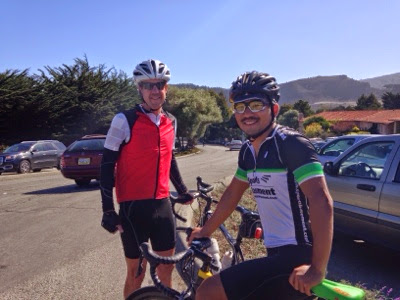
We start pedaling through a beautiful winding canyon dotted with sagebrush. Unfortunately the shoulder isn't great, and the gusts of wind are so fierce that it's hard to pedal straight.  Several times we have to stop because we've almost gotten knocked off our bikes. As we consider getting a ride rather than struggling to bike in these conditions, a construction truck stops to see if we need help.  Soon after, a policeman stops and offers to give us a lift. More time in Yosemite and less time on this road? We accept. The policeman is also named Danny and is super friendly.  He tells us about his family, the farm and ranch land that he takes care of when he's not working this job, the local wildlife and geology. Before we know it we're admiring Mono Lake at the foot of Tioga Pass.
Before heading up the pass we stop at a well known restaurant hidden inside of a Mobil gas station.  Here we enjoy a roasted veggie sandwich, vegetarian chili with cheese over fries and salad.  Everything is incredibly tasty!
Stomachs uncomfortably full, we begin to climb our highest pass yet.  In front of us are stark granite cliffs, jagged against the sky.
Slowly we pass a mountain clearly shaped by an enormous glacier. All around are small streams dripping their way through the dry landscape, and in the distance a beautiful waterfall. We pass some photographers doing work for gg3D.com; take a look at their site!
As we near the top of the pass, we look back and can see the gorge we've been climbing through and row after row of deserty mountains stretching to the horizon.  Quite the sight.
The road levels out and we reach the Tioga entrance station. We're officially in Yosemite at 9,945ft!

It's really cold, so we layer up and make our descent to Tuolumne Meadows, where we get a wilderness permit for our backpacking trip!

Thursday, Oct. 16th
Tuolumne Meadows to Evelyn Lake
We convert bikes to backpacks, then hide our biking stuff in the forest and head out on the trail. The trail we start off on parallels the road and the Tuolumne River, which is super low but still glossy and beautiful. After a bit we turn right onto the John Muir Trail and break out of the forest into a giant meadow. This trail is clearly worn by many feet. It's amazing to think of all the people who have walked here, many of our friends among them. (Danny's side note: and me just over two years ago!) The meadow is filled with golden grasses and a small muddy river.  On either side of us are granite cliffs that seem to get taller as we walk. We can't continue on this trail; it would take us out of the park.  Instead we turn right and hike up into a forest of lodgepole pines. We're pleasantly surprised to find a small stream where we stop to have lunch.
Afterwards we continue to hike up through the forest until we break out into a meadow dotted with small granite boulders and trees. Slowly we make our way into the alpine zone and reach a saddle with a breathtaking view. Behind us is a train of mountains that looks like a series of ocean waves made from granite. Next to these, in sharp contrast, are sheer, dark grey cliffs.  Closer to us are jumbled cliffs that turn into a blocky ridge connecting to our saddle. Ahead is Evelyn Lake, clear and blue.
In the meadow by the lake, mountain bluebirds are playing, their wings flashing bright blue in the sun.  Above us is a small rainbow, although curiously, no rain is in sight. We camp on a small ridge where we watch the sunset illuminate the sky in pastel hues of pink, orange, and yellow.

Friday, Oct. 17th
Evelyn Lake to Merced Lake
We pack up and head down into the valley we enjoyed from our perch last night. Soon we're upon another clear alpine lake and stop to get water. A bit further on we reach Vogelsang Alpine Camp. Now it's a ghost town, but I can imagine how busy it must be in the summer.  There are little cabins, restrooms, and platforms for large stationary tents. I didn't know such places existed!
We continue past and up towards Vogelsang Pass. We pass some huge boulders and find one that looks fun to climb.  There are big chunks of crystal that stick out from the rocks and make great holds. We play around on it for a bit.

Continuing to hike, we evaluate whether we'll be able to go up Vogelsang Peak.  It seems like there's a good route! We drop our packs and scramble up. There's a bit of a trail here and there, but mostly we just find our own way. We're at the top in no time, elevation 11,493 ft. The view is just spectacular. Looking SE there's a mountain so clearly carved by a glacier you can imagine how it must have looked. Now there's a series of 6 lakes, each at a slightly lower elevation than the last. To the west we can see Half Dome, looking like a shiny bald head among the other more jumbled ridge lines. To the north is the same series of granite peaks we saw yesterday, row after row, streaked and striated.  It's quite a sight. We linger for a while, enjoying the view, then head down and have lunch.
In the early afternoon, our trail takes us up and over the mountain saddle and then down into the valley of Lewis Creek.  We follow this creek all the way to Merced Lake, dropping 4,000+ ft. in elevation. Slowly the forest changes from primarily lodgepole to limber pines, red firs, and the occasional cluster of golden aspens. We enjoy watching Lewis Creek pour over granite slabs and dance around boulders. By the lake we walk into a quite grove of giant white firs and jeffrey pines. My legs are quite sore, but it's been an incredible day.
We camp on a ridge overlooking the lake.  As we eat dinner the sun sets between the trees in a blaze of purple and pink.

Saturday, Oct. 18th
Merced Lake to Half Dome
The sun is just rising over the mountains as we head out. This morning we're in a world of granite.  The river pools and waterfalls down granite slabs to our left, we hike along granite slabs, our path is lined with granite boulders, and all around us rise smooth granite cliffs streaked in white and black. Our trail winds up, down, and around the Merced river. At points we walk away from the granite and onto sandy paths through the forest. We pass countless waterfalls, even if we can't see them we hear them, the water dancing its way through the maze of granite. It's a perfect morning, not a cloud in the sky.
After a bit we enter an area recently burned by a fire caused by a lightning strike. The trees stand tall and black. Many have fallen. Stepping off the trail puts us in ash up to our ankles. It's a strange landscape. The only signs of life that we detect are some baby green ferns making their way up through the ash, a couple of woodpeckers, and some massive sugar pine cones.  We find one that's ~50cm long! Here we meet Frank and Mona, two Germans backpacking through the park. We hike with them for a bit and enjoy chatting.
Around lunch, we part ways and stop by a creek where we eat some food, wash our things, and enjoy the warm sun. When we begin our ascent to Half Dome, my legs start to burn.  All the biking and hiking without much rest is taking its toll.  Danny takes some of my stuff, and we continue. Partway up the Half Dome trail we do some scouting and find a perfect spot for our tent: perched on the side of Yosemite Valley. The enormous smooth granite cliffs forming the valley are like nothing I've ever seen before. From here we can see all the landmarks, Half Dome, El Cap, the Three Brothers, and Clouds Rest. Impressive to say the least. Everything except water and layers left behind, we scramble up the rest of the trail. Up top there are no more trees, and we begin to climb large granite steps. The final part of the ascent involves going up two cables, now down for the season. We're not sure about going up, but then we start talking to a climber who has just come down.  In an extremely generous gesture he gives me a new sling and carabiner to attach to the cables so that I'll be safe while climbing.  How incredibly nice! I'm so grateful.
Walking up, the granite is grippier than I expected, but there's still a bit of a climb and I have to take a few breaks on the way up. All the effort is worth it.  Up top it's only me and Danny watching the sun begin to set over the valley. Absolutely magical.
As we head down, the sun casts Half Dome's monstrous shadow on the ridge and backlights it with yellow and orange streaks.  Back at the tent eating dinner, we watch the stars and Milky Way slowly emerge.

Sunday, Oct. 19th
Half Dome to Sunrise
Before leaving in the morning we take a few moments to enjoy our amazing location on the edge of the valley. It's incredible to watch birds swoop and soar over the granite abyss. It warms up as the sun rises and we begin to hike, first down off the Half Dome trail, then a stop to get water by the John Muir Trail, then up and up and up. We slowly climb about 3,000 ft of elevation. At first we walk through coniferous forest, then we emerge back into a landscape of granite, mountain laurel, and buckthorn with scattered trees. Rising before us are immense granite pinnacles, but we walk past them to get to Cloud's Rest at almost 10,000 ft. It's been quiet all morning- we've only glimpsed one other person- so it's a surprise when we get to the top there's a bunch of other people there. They all walked from Tenaya Lake, the much shorter, easier route. They're being rather loud and obnoxious, but I don't care because the view is incredible. Ahead of us is Yosemite Valley, looking even grander than it did this morning (if possible). We have a great view of Half Dome, with the top of Sentinel Dome peeking out just above it. Behind us is Little Yosemite Valley and the swath of  burned forest we walked through yesterday. The backdrop to all of this is those iconic, jagged granite peaks. We stay for a while, enjoying, reading, and painting.

Early afternoon, we decide that it's time to continue, so we hike back down into the rolling hills of the alpine, staying around 9,000 ft for the rest of the day. Late afternoon we reach Sunrise Lakes, gorgeous clear lakes perfectly reflecting the sky. From here we hike out into an expanse of meadow.  It takes us a while to find a place to camp because the meadow grasses have determinedly advanced in among the trees.  The sun sets pink over the granite hills.

Monday, Oct. 20th
Sunrise to Tenaya Lake
Cathedral Peak
There's frost on the tent when we wake up, but slowly the sun warms us up.  A short hike brings us up over Cathedral Pass and from there we evaluate how best to climb Cathedral Peak. Leaving our packs by the trail, we set off. After the first ridge we pick up what appears to be a trail. Closer to the top we see a sign that the 'trail' we were on is an unofficial one. Since so many climbers come here, they're trying to establish one permanent trail and reduce erosion.  From then on we try to follow the path marked by carabiners. As we climb up I admire the layered rock faces that form the jagged peaks of Cathedral. We make it to the ridge and realize that a climb to the top would require some rock climbing gear, or just be really sketchy. We decide not to attempt it. The view from here is more than enough to please me. On both sides are beautiful deep blue lakes, their waters rippling in the wind. Ahead are several smooth granite domes poking up from the forest. But right now, what's really cool are the clouds. They've been blown into layered orbs and circles so that they look sort of like UFOs. We also see some large, puffy storm like clouds rolling over the horizon, which make us decide that it's time to be on our way.
Off the peak, we have lunch then hike out. Thankfully, it's mostly downhill, and the few groups of people we meet assure us that the weather should remain fair. Late afternoon we're reunited with our bikes. Yay! We repack our things and ride down the road to Tenaya Lake. I do a painting as the sun sets.  A mountain lights up pink in the distance.

Tuesday, Oct. 21st
Our day starts off poorly with a ranger citing us for camping out of bounds.  We're not sure how we're supposed to bike the road if our bikes are not allowed to be parked on the road overnight, nor are they allowed to be taken into the wilderness. We do our best to forget our frustration with rule-following officials and enjoy the ride down the Tioga Road.  At first there are lots of ups and downs, but after 25 miles or so we begin an incredible descent that brings us right into Yosemite Valley.  Even though we're still in the park, we feel completely removed from the wilderness.  There are cars, people, and buildings everywhere.  The village includes a post office, store, gallery, restaurants, hotels, a court, and a jail! We eat some delicious pizza then meet up with my friend Chad who I met biking cross-country in college.  Currently, he has an awesome deal working for IT in the park and has generously offered to let us stay at his place.  It's so great to see him! We use the afternoon to run some errands, we finally sent our bear cans off in the mail!!, then spend the evening chatting and  making delicious food.  Chad is working on an awesome app for climbers.  Currently it only has info for Yosemite, but he's hoping to expand it to include many other areas.  From what I can tell, it's way more useful than mountain project. (Danny's side note: Mountain Project is a popular online resource and app for rock climbing.)
We're sleeping warm and inside tonight.

Tuesday, October 14, 2014

Monitor Pass

We started today with a long descent from Luther Pass.  With the wind at our backs, we flew downhill at 38 mph for five miles.  The fairytale ended when we turned into the wind, and going down is always bittersweet when you know there's a big pass coming up.  Predictably, we soon began to climb.  The scenery continued to be as pretty as ever with the leaves turning, and the ascent was gradual at first while following a river.
Then we saw this sign:
Fortunately we weren't going that way.  Our pass was not going to be easy, however.  I googled it and found that it is featured in a local "death ride."  A local in Markleeville, a small town we stopped in, said, "Monitor Pass?  I don't even like to take my car on that."  Up we went, much preferring our route to the 24% grade the other way.  We sustained a 9-10% grade for about eight miles with sections of probably 12% and a flat section here and there.  From the bottom, we went up almost 3,000 feet.  People think Alaska was tough riding, but this was much more difficult than any pass we did there!  
Fortunately we had the help of the wind for some of it, and our increasing elevation provided us with ever-better views.  We finally reached the top around 1 pm and sat down for a long lunch.
"Monitor Pass, Elevation 8314, Dedicated 9-12-54" 

After lunch we fiddled with our brakes for a few minutes, making sure they were working as well as possible, then set off on the descent.  This was the steep side, apparently, and I was able to maintain a constant 30 mph or so in the strong headwind simply by sitting upright.
Our destination: the bottom of that valley.  A scenic few miles!
While the headwind was good for limiting speed on the steep downhill, it wasn't so good once we reached the bottom.  It was absolutely blasting from the south.  A wind forecast indicated winds of up to 35 mph; a few strong gusts stopped us completely, forcing us to wait for them to relent before starting to pedal again.  We slogged about ten miles through the wind before stopping in the little town of Walker.  The wind is still roaring; it sounds like waves are crashing on top of the tent.  Hopefully it abates somewhat by tomorrow.

Bike Paths and Lake Tahoe, October 13

We woke up at Spencer's house around 7 and made some breakfast: oatmeal for Tam and eggs, six of them, for me.  After packing up and saying our goodbyes to Spencer and his roommates, we headed out, somewhat unwillingly, into the frigid morning.  We struggled to warm up; fortunately some hills helped us out! After a little while we hopped on a bike path paralleling the road, and that took us to the west shore of Lake Tahoe.  
With big mountains lining the horizon and the lake itself sprawling blue in front of us, I could understand why this area is so popular for skiing and vacationing.  The scenic bike path paralleled the road and the lake shore for a number of miles, finally ending a few miles before Emerald Bay, a picturesque inlet with an island. We climbed a long, steep hill to get there, and the views of the lake and the bay were amazing.  We stopped for lunch in a scenic, touristy area, and were much entertained by the tourists among us. Only a few amid the throngs took the time to enjoy the view in real life rather than through the screen of a camera.  I am definitely guilty of this, too, but it's funny to see it in others.


After lunch and a short climb out of Emerald Bay, we descended some steep switchbacks and found another bike path.  The south shore of the lake has a lot of beaches, but we couldn't see the lake anymore from the road.  Trees lined our path now.  And stores, as we reached the more populated areas.  We ran into a health food store and picked up some bulk items: dehydrated bean soups, chocolate, and enough couscous to last us for a month or so. 
Away from Tahoe we now headed on highway 89.  Lo and behold, another bike path!  The traffic wasn't terrible, and the shoulder had been decent, but a nice path just for us is always appreciated!  This one ended soon, however.  A few more miles in, we began to climb the dreaded Luther Pass.  At 7,740 feet, it would be a 1,500-foot vertical climb from the lake.  Impending darkness was a good motivator, so we powered up it and reached the top in no time.  Aspens and other turning deciduous trees added some color to our scenery, and streaks of clouds lay stationary among the bluest of blue skies.  We were really in the Sierras now, the Range of Light!
Our descent from the pass was over quickly at almost 40 mph, and we stopped in a campground for the night.  It's our favorite kind of campground: the closed-for-the-season kind.  You can't get a car past the gate, but bikes are no problem!  No obnoxious camping neophytes to attract bears or disturb us, and no exorbitant fees to pay.