Monday, September 21, 2015

Bike-trekking the Huayhuash, September 5th-21st

Huaraz-Pastoruri-Huallanca-Huayhuash-Oyon

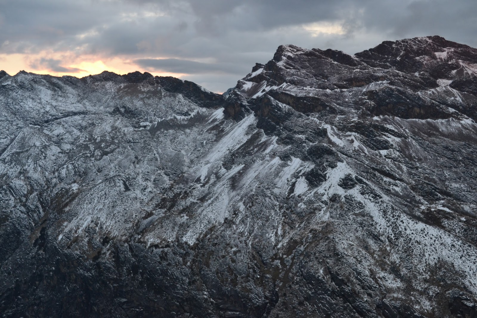
One of many spectacular vistas from the road to Pastoruri
From Tam´s journal:

We spend much longer in Huaraz than planned.  In light of the challenging mountain passes ahead, we decide to cut down even more on our stuff and go rackless! Getting rid of our racks has several pros:
1) It forces us to get rid of unnecessary things that we don't use often, such as a bird field guide from Ecuador, the ukuleles, sadly, and extra t-shirts and bike parts, to name a few.
2) It allows us to run a wider back tire. Since our racks were already stretched to accommodate disc brakes, there wasn't much space back there for a bigger tire. We probably could have bent the racks more to fit, but lacking the proper tools, it was much easier to just remove them.
3) Progress! We've been consistantly trying to improve and lighten our loads as we've traveled south, and this is just the next step.

Of course, it comes with some challenges as well. We spend a good portion of two days shopping around at hardware stores and creating holders to support two dry bags on the front fork, not to mention finding good quality dry bags to hold our stuff in the new set-up... but that's another story.  When we're finally ready to leave on the morning of the 13th, as we're riding out of town Danny realizes that his front derailleur is hitting his new, wider back tire. He actually changed his bottom bracket a few days before so this wouldn´t happen, but with his inset chainrings and the new tire, it´s still happening. We attempt some roadside maintenance and only succeed in intentionally breaking the part of the derailleur closest to the wheel. It´s better than it was, but it´s not enough. We need a bike shop. It's Sunday, so of course no shops are open. Looks like we're staying another day.

Tools available for derailer adjustment: Leatherman multitool, rock, and broken bits of brick
The time passes faster than we expect. An unexpected run-in with our new friend and fellow touring cyclist, Chris, results in a six hour stay at a local coffee shop, eating, drinking, sharing stories, and of course laughing a lot.


Chris, originally from England, has bicycled all over the world and is an amazing guy.  Check out his blog here.

Chris´s mug in an upside down mug
Morning of the 14th we're able to put a spacer on Danny's bottom bracket and finally roll out. It's a bit bittersweet leaving town. I feel like we've achieved so much in our short stay here. We've climbed an 18,000+ foot mountain, changed up our setup, and given our style a bit of a make-over. What I mean by this last comment is that a nice lady at the market replaced the broken zipper on my fleece with a bright pink one, and we've both aquired a ¨buff,¨ that lightweight circle of fabric that can serve as a hat, scarf, or numerous other things. I used to think that these were useless pieces of fabric, more useful for fashion than anything else, but now I see how practical they can be.

At the same time, we're both psyched to be leaving the noisy city where marching bands roam the streets and fireworks explode at all hours of the day and night. It's time to get back to the mountains. Slowly, our legs remember how to bike and we speed down a paved road until the turn-off to the National Park and Pastoruri, where we are able to find a place to wild camp for the night,

Sept. 15th
In the morning a dirt road takes us to the Huascaran National Park entrance. The guards here are a bit strange. One talks at us constantly and is clearly disappointed when he sees that we have already paid our entrance fee. The second one asks how long we have spent in Peru, and when I tell him that we'll be here a couple of months, he glares at me and says, "you must be rich." It's not a very kind welcome to the park.
Of course, I understand that having had the opportunity to work in the U.S. has set us up with more money than the typical Peruvian makes, and obviously everyone´s situation is different. But the biggest difference I see is that we have chosen to use our money to travel, whereas the vast majority of people use their money to raise a family. Our priorities are simply different. Bike travel can be extremely economical, and I really believe that most Peruvians with a decent job, such as a park ranger, could save up and travel around their country for a few months if they so chose.
And then there are many Peruvians who really don't make any money, those who are rural subsistence farmers. I can´t ignore that we have so much more than they do, but I still wish that they could see us for more than our money. Why is the first question so often "how much did your bike cost?" and not, "where are you from?" or "what's your name?" I guess that's capitalism for you.

The entrance to the park is improved by an interpretive center which discusses the affects of climate change on the local communities and the mountain ecosystems. It's extremely well done and reminiscent of something that you would find in a North American National Park, except the electricity doesn't work so it's very dark.

Along the park road there are various displays showcasing local natural wonders, and we have a great time exploring and enjoying the views of the surrounding snowy peaks. We go over a pass and set a new altitude record for the bikes, 15,700 feet or so!  Beautiful wild camping tonight.

A bubbling pool. Geothermal?

Tam with a big Puya plant

Glacial turquoise mixing with mineral red


Interesting mountains

Sept. 16th
The road quality is incredible and we spend all morning enjoying the scenery, since we don't have to steer around rocks and potholes. Some ups and downs bring us to an enormous, circular, sweeping vista. The valley floor looks like a water color palete, watery blues, greens and reds swirled together artfully and then left to dry. In some areas the green forms mossy clumps, in others it represents short grasses. I'm not sure whether the grasses are naturally short or have been mowed that way by the ubiquitous livestock this park protects. From the undulating valley floor rise hills and ridges. The layers of rock put their geological history on full display. In my mind the many ridgelines take on forms and personalities, as amorphous cloud shapes sometimes do in the sky. I see a great caterpillar with a twisted face, a gigantic fish, and a series of enormous mushrooms emerging from the earth. Above all of this -- snowy peaks. Standing in one place and turning my head as far as it can go I can see majesty in every direction.

The top of our pass is a new altitude record, just under 16,000 feet! Then a paved descent to the town of Huallanca where we stock up on food for the next few days.

Mossy clumps

Mountains everywhere!

Quite scenic! Tiny Tam riding on the left

Picture-perfect riding

The bullring in Huallanca, ¨Ranching and bullfighting capital of Ancash¨

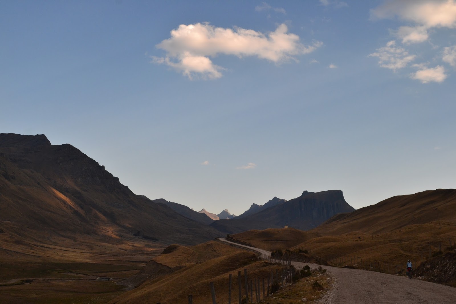
South of Huallanca. Time to find a campsite

Sept. 17th
We start off riding on the main dirt road and, after breakfast, turn off onto a small donkey track that will take us to the Huayhuash (pronounced WHY-wash) trek. Within moments, the trail goes from ridable, to mud, to rock-garden. As we edge our way along the narrow trail and lift our bikes over boulders, I feel like I'm rock climbing with my bike. When our trail finally reaches a new valley we descend off the trail to the soft green below with the hope that no trail will be better than a rocky one. The valley floor turns out to be covered in a very interesting green plant. Star shaped, small and tough, it forms a carpet, and when you tap on it, it sounds almost hollow beneath. As we half ride, half walk, I feel like I'm traveling over a green glacier. In places, holes like moulins open up exposing watery, marshy depths. In other places there are vegetation crevasses to traverse, rivers flowing below the carpet.

A rare rideable section, no trail for the rocks to accumulate on 
An extra arm workout
Early afternoon we spot a gleam of hope in the distance: a road! The rocky road feels magical after our marshy morning hike-a-bike, and reaching the top of the pass, the views are spectacular! Tremendous snowy peaks tower in the distance, and a lake below reflects them in perfect detail. Marveling at the reflections in the lake we realize that they are caused by oily mining residue. The whole valley is smeared in a nasty reddish orange. Gross. Mining has really destroyed the landscape in so many of these remote mountains.  But... if there weren't mines there wouldn´t be roads for us to ride, and we'd still be on that donkey trail....

Crazy reflections

¨We care for the ozone layer.¨  That´s nice.

Big boulder, bitty bike
Our camping spot is epic.  Outside the tent door is a wide waterfall overflowing with sparking sheets of water, and just beyond, perfectly pointed peaks painted in purples and pinks by a mix of clouds and setting sun.

Pretty nice camping spot

Painted sky
Sept 18th
We begin our day on the Huayhuash trail. For those of you unfamiliar with Peru, this trail is a popular trekking circuit that passes an insane number of huge snowy peaks, including the second-highest in Peru, and beautiful mountain lakes.  Most of the circuit is at very high altitude, so it's a good acclimatization hike for those hoping to climb one of the bigger mountains. The trail is made for hiking, but we're hoping to bike as much of it as we can.

Only a little ways into our ride we are stopped by a lady who steps in front of us and hits a booklet of tickets with her hand. She stands there and looks at the ground for about a minute. We look at each other and back to her a number of times. Finally Danny asks her, "Is there something you'd like to say to us?" Through her mumbled words we make out that we are supposed to pay S40 (roughly US13) each to pass through their community (a collection of about four huts). When I ask the lady what the money is used for, she mumbles something else indistinct into her scarf. The tickets that we have purchased say that they are for conservation, although the picture of the cow on the front makes it clear that their definition is different from ours, that the focus is on conserving the local communities and not natural places -- we are surrounded by ranchland. Rather confused, and feeling a little bit like we were just robbed, we continue on.

We learn later that this is a common practice along the trail. At each camping area a local community charges a fee for passing through. These communities aren't actually near the trail -- they are in nearby valleys -- and we heard different explanations for what the money is used for. The second guy who charged us said it was to go towards improving a local school. The third guy who charged us said it was going to improving a campsite which we didn´t use, and a friendly backpacker explained to us that there used to be lots of robberies along this route, but after the cuota (fee) system was imposed, there haven't been any, possibly because the people charging us now pay the people who were doing the robbing before. Well, at least now it's organized, right?

The whole thing makes us frustrated. It would be easy for the locals to set up small businesses here providing a small hospedaje, cold showers, local fish, or snacks. People would be happy to pay for and support these things. It´s not the fault of the locals; they don't know any better. They ask for money to support a vague notion of ¨conservation¨ or ¨protection¨ and the backpackers pay. It's the system at fault. Education is needed.

Apparently hiking the whole loop costs around S180 (roughly US60) per person. We got away with paying just S85 (roughly US28) each on the section we did.

As this is a hiking trail, we meet several friendly backpackers along the way. They're going about the same speed we are on one of the more gradual ascents, and we enjoy a chat. Hope you folks had a great trip!

After a great descent where we're actually able to ride on some beautiful singletrack (this is my first time ever riding singletrack -- got to start somewhere right?), we have lunch on the edge of a giant turquoise lake bordered by glaciated mountains. A local guide is setting up camp behind us for his clients who are trailing behind. He and his crew of three donkeys have hauled up three tents, big backpacks, food, woolen blankets, a giant propane tank, and more that we can't see. It all looks very luxurious. I think that this is the Peruvian version of RV camping.

Bike meets mountains at Laguna Carhuacocha. 

Local improvements: solar panel on thatched roof of adobe hut
In the afternoon we head up a second pass. The ascent proves to be one of the most difficult things I have ever done. The trail is steep, narrow and rocky. My arm muscles, long out of use, are burning, and my bike moves ahead in shaking increments. The feeling of exhausted joy we experience hours later when the trail flattens out is hard to explain. We set up camp as it starts to rain.

This was one of the less-steep sections where I could balance my bike and my camera
Sept. 19th
In the morning we struggle through the rest of the climb over the pass, feeling the burn from yesterday. A descent brings us to the Huayhuash campsite for lunch, where the friendly local guide we met yesterday (with the donkey RV system) shares some bread with us. We have enough food, but we're running a bit low on certain items because all the hiking/biking is taking longer than we expected. The fresh bread is greatly appreciated. I can't help thinking that perhaps all the bread we have given out to locals asking for money has finally come back around to us.

The next pass turns out to be pleasingly gradual and we're able to ride sections of it.  I'm able to look past my physical discomfort to enjoy a large peak covered in a glistening glacier that seems to be larger every time I look at it. Across the valley from this glittering monster is an extremely tall waterfall that sends a gentle veil of water showering to the valley floor. A few false summits, and finally we're at the top. New mountains on the horizon look as if they've been garnished with whipped cream. As the sunset starts to light up the sky and we set up camp, we're in tired awe of the landscape around us.

Rideable trail! 

Another amazing camp spot

I never tire of watching sunsets
Sept. 20th
It appears that the deep blue lake below us was once a quarry. The sides up to a certain point are white and rocky, stripped of vegetation, and a jagged island in the middle has a road scraped across it. Our trail traverses along the lake edge and then down to where the electricity is made. I can't help thinking that the trail would have less ups and downs if we didn't have to go around the dam area. (no pun intended.)

From here we begin the slow ascent up our last pass of the journey. As we climb it begins to rain, then hail, then snow. This is a new experience: pushing our bikes on a narrow trail through a snowstorm. Luckily visibility stays clear enough and as we reach the top of the pass the sun begins to shine. At the top we look down and see a good quality road! Hooray! Smooth riding again! A long descent takes us into the town of Oyon where we happily find a small hospedaje to rest and recover.

Smooth riding

Beautiful descent

Mountains and bikes, two of our favorite things (if you couldn´t already tell)
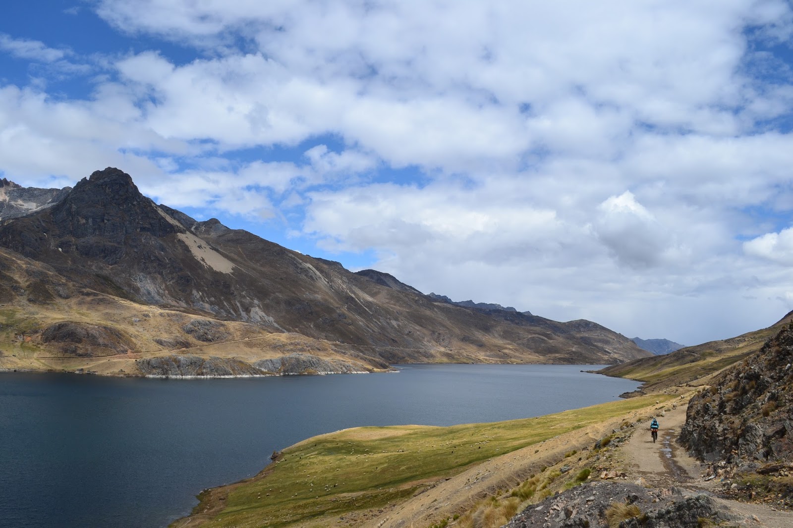
Laguna Surasaca

Sept. 21st
A young child swaddled on the back of the cleaning lady at our hospedaje
A much deserved rest day! A visit to the market this morning left us well provisioned with delicious fruits, veggies and fresh bread. Time to charge the phone, enjoy some podcasts, and eat plenty of cachangas (Peru´s version of fried dough)!


If you're wondering about our new set-up and how it´s working... we're still re-arranging bags and figuring out how to make them work best. We´ll put up a link to the gear page when we've settled on something we like.


Route Notes:
Huaraz to Huallanca: South on the main paved road out of Huaraz, we took the signed left after about 40km onto the dirt road to Pastoruri. Well surfaced and water is plentiful. After the turnoff to the glacier and the first pass soon after, the scenery gets better and the road smoother. Really good cycling.
A descent brought us to the main paved road and a left to Huallanca, where there are stores and accommodation and even, if I remember correctly, a bank.

Huallanca to Oyon: There are no connecting roads through the Huayhuash mountains, so the route we took linked up with the eastern side of the popular Huayhuash trekking circuit, in total probably about a third of the trek. Dan from fatcycling was kind enough to send us his GPX files, so we were able to follow the next part with ease. 
We headed south out of Huallanca asking for Huayhuash. The road is well surfaced dirt following a wide valley. At kilometer marker 23 we took the rocky trail on the left. The trail takes you around to and along the right side of a different wide valley, lots of pushing involved, a few hours at least due to rocks. After getting fed up with pushing and carrying, we tried simply freestyling by the river but that wasn´t much faster. We followed the valley until picking up a rocky road near the top of the pass that took us over the top and down the other side.
The next valley is where we picked up the Huayhuash circuit near Laguna Mitucocha. You´ll see the trail across the river on the right near the bottom of the descent. The trail is world-class in parts and always scenic, but mostly the surface is very rocky and unrideable. Tons of pushing and carrying. We followed the sendero for two days and 34 km to the dam at Laguna Viconga, where, instead of heading west along the circuit and dropping into the next valley, we took a different, smaller trail up to Abra Portachuelo and down to Laguna Surasaca. The road after that last pass was absolutely fantastic, scenic and smooth, and then it´s a few km of straightforward riding, mostly downhill, to Oyon. Shops, restaurants, internet cafes, accommodation, and a bank with an ATM.

The consistently unrideable surface, thousands of cows, and non-negotiable fees meant that bikepacking the Huayhuash circuit was not the remote singletrack experience we had hoped for. The trek itself is beautiful and worth doing, but I would advise against bringing the bike unless you have ample off-road skills and are okay with pushing and carrying, sometimes for long stretches. If you would prefer to stick to roads, I would highly recommend the road up to Pastoruri and then heading west to Conococha, where you can meet up with Peru´s Great Divide. Or, from Huallanca, head south and continue following the road to Chiquian, where the official Huayhuash trek begins, and then to Conococha. Both of those routes take you way out of the way, but hey, bike touring isn´t about getting anywhere fast.

Thursday, September 10, 2015

15 Months: Stats, Mountain Climbing, and a Guest Blogger

Miles biked: 12,951 miles (20,843 kilometers), give or take a few hundred miles
Bird species positively identified: 490
Highest altitude achieved: 18,655 feet (5,686 meters), Vallunaraju, Cordillera Blanca, Peru
Highest altitude biked: 15,633 feet (4767 meters), Portachuela de Llanganuco, Cordillera Blanca, Peru
4000 meter (13,100 foot) passes ascended by bike: 9
Number of cities/towns visited whose names end in the suffix "-bamba" (ie Riobamba): 7

We´ve been working furiously here in Huaraz to fix up our bikes and prepare them for the next remote segment of our trip, but we took a break from the errands to take advantage of our time in this mecca of mountaineering. Not having much experience, even the apparently moderate Vallunaraju provided quite a challenge. I´ll let the photos take it from here...

An afternoon snowstorm at base camp buried our tent and left the surrounding peaks covered in a shimmering layer of white
Sunrise while heading up the glacier

You can see the city of Huaraz far below on the right side of the photo
A beautiful morning view of Huascaran
Making our way up, our guide Stephen leading the way

Lots of snow!

The last push to the summit
Made it to the top! 18,655 feet

The photographer

The obligatory couple shot

Tam´s parents, Andie and Michel, have also been having plenty of adventures! They are our guest bloggers, and here is their post:


Tam´s parent's here with a guest blog appearance! So we thought a trip to the northwest would be a good idea mid-August to escape the heat of southern Georgia. We picked Portland, as a country music festival was happening there and it's a reasonable drive to Walla Walla where there are many wineries which we would enjoy tasting out. Once we got the travel arrangements done we realised we would be heading to an area that our cyclists had gone through nearly a year ago. So a great opportunity to visit a few of the wonderful people they have met during their long journey.

Results: 

Nice couple!
1- arrived in Portland where a record 25th day of 90 degree weather was achieved. So much for escaping the heat, but I guess it was a dryer heat...

2- Tasted 21 different grape varieties in all sort of combinations (i.e. 100% semillion! And some blends of 6 grapes). Success! Quite an area to enjoy.

3- we took a drive towards Pomeroy and dropped in to see Curt and Julie (see blog post of 9/17/14). They were a bit shocked at first to see strangers show up bearing a basket of goodies. After introductions they quickly welcomed us in their home and regaled in the recollections of Tam, Danny and at that time Cameron's visit. It was great to personally be able to thank them for their hospitality. 


Happy at the farm

The next day we stopped by the Welcome Table farm (See blog posts 9/18-9/21) and met up with Liz and the farm family. Liz came out of the fields where she was picking corn to see who the announced visitors were, and her confused expression changed quickly to astonished enjoyment after we mentioned Tam and Danny. We had a nice chat on her work and life at the farm; she is enjoying it greatly and we can see her happiness shine through.


It was a terrific experience for us, and our future travels will seek to connect with some more of the fabulous people that Tam and Danny have met.


Andie and Michel

P.S. The country music festival was fabulous fun!


Saturday, September 5, 2015

El Silencio, August 21-September 5

Cajabamba-Curgos-El Eden-Sarin-Munmalca-Paragon-Pelegatos-Pampas-Cochaconchucos-Conchucos-Sihuas-Sicsibamba-Pomabamba-Piscobamba-Llumpa-Yanama-Yungay-Carhuaz-Huaraz

When I was younger, I used to read Cosmo magazine and wonder about what it felt like to be one of the celebrities featured in its pages. After riding for a few weeks in Peru, I can confidently say I know what it feels like to always be in the spotlight... just for a lot less money.

As we're riding through the rural countryside, people stop whatever they're doing and stare when we pass by. Sometimes they call out to their friends to come see, other times they yell out "gringo!" and point and gesture frantically like we're the most exciting thing that has happened in months. And perhaps we are. Most likely the only people they see in their small villages are those who have lived there for their whole lives.
And just as celebrities in the U.S. are meticulously observed and evaluated by the American public, our actions here are under scrutiny as well. If we are the only foreigners that a local villager has ever seen, it stands to reason that they will judge any foreigners they meet in the future off of our actions. Many days I feel like it's my duty to represent the population of the rest of the world--or at least the significant part that can be defined by the word "gringo"--because I am one of the only examples that these people have ever seen. It's a big responsibility.
Thus, even if we're tired, hungry, sick or sore, we're smiling and waving hello, being polite and friendly in any way we can. We're not perfect, but we hope that we can put on a good face for the rest of the world.

Danny here. Tam wrote that last bit, and it seemed pertinent to put here because, as we rode through a clear, cool morning on our narrow, paved road out of Cajabamba, both of us greeted people along the road over one hundred times! Being a celebrity is exhausting, and we were excited to reach the grail of solitude known locally as El Silencio, The Silence. We were to take a back route from Cajabamba straight through the heart of the mountains, stepping off the beaten track onto a longer date with this lonely alpine zone that strikes apprehension and fear deep into the hearts of the locals but exacts the opposite reaction in us. Being in places without houses and people is something we cherish, something we´ve been short on in the last few months.

Had to laugh at this sign!
We eagerly turned off our paved road towards the village of Curgos, plowing our way through white sand, a byproduct of all the mining in the area. After picking up some supplies, we descended into a deep gorge and, impossibly, in a space where there was barely room for the river and the road, came upon the complejo turistico of El Eden. Hot springs, private baths, and a restaurant were crammed in a flat slot beneath the narrow rock walls, and we camped in a quiet field next to the bathhouse for the night.

El Eden

Another bright morning saw us riding up a wider canyon through the towns of Sarin and Munmalca. The main road runs around Munmalca, and we stopped to get water at the only building we saw: the health center. There were a number of young women sitting outside the modern building among numerous rambunctious children. Tam sat with the bikes as I pushed through the double doors with our water bottles. When I came out again a few minutes later, full bottles in hand, Tam nodded over to the young mothers. I followed her gaze. The children were no longer running around, but held close under protective arms. They women were wide-eyed and afraid of Tamara, the sweetest, most kind-hearted person in the world (I might be biased, but only a little bit). Why? We speculated about various reasons as we climbed up out of Munmalca. In northern Central America, we had heard rumors of foreigners coming to steal children. Maybe this was related. A few days later I told a local guy about the fear we´ve seen in some people, and he responded by saying that there is great anxiety about foreigners coming and killing people to harvest their organs. I would have laughed at the ludicrousness of this notion if only it weren´t also so frightening. Now, more than anything, I´m ashamed to provoke those emotions in people. Of course I can´t be totally sure, but I really doubt that this kind of thing happens. Maybe something like it happened somewhere, once, and it´s now been blown way out of proportion by nervous gossiping and a lack of objectivity. All we can do is be friendly and hope they see us for the harmless travelers we are.

Canyon riding on the way to Sarin

Excited even more than before to reach El Silencio, we finally did it. That night we camped in the paramo among tussocks and rocks, and it was glorious. We took in the silence over the next day as well, enjoying the cool wind in our hair and the gorgeous views of immense mountains and sprawling valleys all around. Unfortunately, the natural beauty of the area was marred by mines, scars on the green hillsides. Streams we attempted to drink from had amounts of metals so high that we chose to be thirsty for a little while. Mining accounts for 60% of Peru´s total exports, but seeing (and tasting) its negative effects forces me to ask, ¨At what price?¨

The paramo

Wild camping!

More stars than you can count

Rocky riding.  Evidence of an Inca road on the right?
If you're wondering how a girl who was once afraid of riding her bike off pavement ended up here, check out this little article I wrote. I hope it inspires others to put themselves out there and challenge themselves.

At the top of the second pass

Clear evidence of mining

After cresting the top of the final pass around 14,400 feet, we began the big descent to Pampas. Switchbacking around a massive, horseshoe-shaped valley, we came around a bend and were greeted with a big surprise:

Laguna Pelegatos
Wheeeeee!

Beautiful sunset scenery

Don´t fall...
The rest of the descent was equally scenic, fun, and harrowing, with the road cut directly into the side of an almost vertical valley, its switchbacks so tight that they didn´t even show up on our digital map. We arrived in Pampas around 5:30 hoping to eat a meal and fall asleep right after. Fate had other plans. We had randomly arrived during a multi-day fiesta, and our first glance up at the main square showed a marching band walking by, screeching comically. The same band marched into an alley facing away from the main square, for whatever reason, and stayed there playing late into the night. By 7:30 the next morning they were in their alley again, tooting and squeaking. Pampas seemed like a tranquil place, usually, but we were happy to leave. Climbing up out of town provided some relief, and when we reached the top of the pass a few miles away, we looked down at the town 1,500 feet below and were astounded to hear the band still playing their hearts out as if they hadn´t already been playing the same song for the last twelve hours, as if every time the rhythm were fresh and new.

The fun descent down to Cochaconchucos led us to new adventures: the road was closed. We humped our bikes down a few flights of stairs and around some big gravel piles then rode a few paved kilometers to Conchucos. This town, which had been founded in the days of the Incas, was the beginning of what we had read about as a remote "high-altitude route" following an old Inca road (perhaps the main artery, the Capac Ñan) over a pass to the foot of the Cordillera Blanca. Of the two routes that existed in this area in 1533, this was the route that Francisco Pizarro decided not to take when he marched his troops to sack Peru's treasure trove, Cuzco. His reason? It was too hilly. That tells you a bit about our next few days. It was mid afternoon, and we immediately set about climbing. This is the norm in the Andes—big uphill, big downhill, big uphill, and so on—so we powered through. All of a sudden the massive face of a jagged, snowy peak appeared in a gap between two ridges. The sight of snow, indicating an altitude just about in the stratosphere, was invigorating. We went up some more, and the view got even better. About this time the sun was setting, and it threw near-horizontal beams of light streaming past the craggy outcrops and enormous sheer faces of rock and ice. The falling shadows, the mountain wind, and the golden hour of blessed sunlight swirled together and multiplied for an intense ride up to a river. While the last shades of orange sky darkened to black, we found a campsite and set up, exhilarated with the big mountains right there, so close we felt we could reach out and brush our fingers on the windswept summits.

The truck in the upper center is dumping more rocks in the road

Lots of farmland

Scenic skies

Tam making her way up

Tam cycling in the last rays of the setting sun

Gorgeous riding

Epic sheep

Shadow selfie

Old Inca road
Our excitement was temporarily detained the next day, however, when we woke up in the early morning sick with food poisoning. The day dragged by with more sun than I ever thought possible at 13,000 feet, and with a flock of sheep and their curious young shepherds who came to check out our tent.

The next day, still weak but slightly more capable of movement, we walked/rode our bikes up the rest of the pass, topping out at about 14,500 feet. From the top we could see more snowy mountains, not just one but the whole Cordillera Blanca, the second highest range in the world! (Behind the Himalayas, of course.) Our excitement was back and amplified by the return of our appetites that night.

This is how you know there´s no traffic. That´s a washed-out culvert in the lower left of the photo.

Fuzzy cacti!

Interesting landscapes all around

And the road ends.

Up and over we go...

...to a new road and incredible views on the other side. Cordillera Blanca in the distance.

Wow.

Taking advantage of some shelters to use as a nice camp spot

Sketchy. We walked around.
Although we were able to descend to Sihuas the next day, the next two days were spent relapsing into sickness and recovering. The most frustrating thing? The dry season in the high mountains was ticking by hour by hour, day by day, and we were powerless to take advantage of it.

But we are cyclists, and we persevere. Leaving Sihuas we descended to the lowest altitude we hope to be for a while—7,800 feet—then climbed right back up to 12,000. During the climb, snowy peaks began to peer out from all over the place, tantalizingly close.

The same day, from Tam´s journal:
By the end of the day we're both tired from all the climbing, and decide to stop just before the top of the pass.  There's nothing like finding a perfect camping spot at the end of a long day. A short path brings us away from the road and into some quiet ranch land.  In front of us is an open flat area with short soft grass and a beautiful view of the mountains; it's as if it were made for us. As we eat dinner, the mountains become silhouettes and the clouds begin to glow in orange and pink. The sky darkens, and the mesh on our tent turns the last rays of the sun into rainbows.

September 1st
In the morning we're up and over the pass in good time. Then a descent takes us into the town of Pomabamba-how many towns have we passes through that have "bamba" as part of thier name?- where we get lunch and do some shopping at the market. Surprisingly, it's almost impossible to find bread. One guy explains patiently that there is no bread today. No bread here on Tuesdays? I'm still learning how things work around here.

The afternoon ride is challenging.  We're battling on this road with dust, speeding colectivos (minibuses), and miniature versions of the surrounding mountains which form the bumpy road surface under our tires. But, everything is made better by the scenery.

At first I don't even notice them. Looking out across the valley I observe the usual farmland and sky. Wait, I realize suddenly, that´s not just sky, there are mountains! Neither of us can find the proper words to describe them. They are like nothing we've ever seen before. Constrasted against the matte browns and greens of the surrounding farmland, the snow seems almost flourescent in the sunlight. As we ride, bits and pieces of the brilliant ridgeline are slowly revealed, and we are rewarded for every pedal.

Big snowy castle up ahead
We stay the night in Piscobamba at a tiny hospedaje. These places are so cheap and cozy that I feel bad asking to camp somewhere for free. The adorable little lady who runs this one has hand knit every single colorful cushion on the chairs and every warm quilt on the beds.

September 2nd
Our morning begins with a long descent into a river valley. In many places the road has been flooded or wiped out by landslides. Bus driving reaches a new level of horror under these conditions.
Imagine us biking along. Ahead of us is a narrow section of road that has been recently wiped away by a landslide. There is a small path blazed through the jumble of loose rocks by recent traffic. On the right are more large loose rocks looking poised to tumble, and on the left, a sheer cliff.  As we observe the road condition and gear down, we are forced to stop by a passing bus. The giant, top-heavy vehicle accelerates as it approaches the landslide area and skids around the corner, wheels churning and sending out sprays of rocks. Somehow it remains upright and continues down the valley. Later we see this same bus stopped for lunch at a small restaurant. Why there is time for a leisurely lunch and not time to slow down on the curves is beyond me. Some days I am very happy to be traveling by bicycle. At least my life is generally in my own hands.

From the river we climb up and then descend down into another river valley. Here we find a small group of houses, one of which appears to be a restaurant.  We have some bread and cheese, so we order eggs and make egg and cheese sandwiches. It's a fantastically delicious lunch, especially with the addition of aji.  Every restaurant has their own flavorful and spicy sauce made from aji, the local spicy pepper.  These sauces have done a lot to make our Peruvian culinary experience more vibrant.

All afternoon we bike through farmland. At this point, I think we have seen every stage of Peruvian house construction:
1. Mixing of mud in a  huge wheelbarrow and shaping it into adobe bricks. A wet and dirty process.
2. Bricks drying in the sun by the side of the road.
3. Bricks being put together into a house.
4. Lumber being cut from the imported eucalyptus trees that grow everywhere.
5. Lumber being laid on top of the first brick layer to form the foundation of a second floor.
6. Completed houses being painted with political propaganda. (Almost every house is decorated with pictures and names of political candidates. We learn later that people let their houses be painted because it's a free coat of paint, and the paint helps preserve the adobe. They might not even support the candidate whose symbol is on their home!)
7. Ready to live in!

Also of interest are the Peruvian hats. We decide that you could write a doctoral thesis on these hats. Every region we pass through has a distinct style and shape, and it's a constant source of entertainment for us. In this particular area, the hats are more rounded, often with a colorful ribbon or flowers used to decorate the rim. Women's hats are usually made from some sort of straw, and men's hats from felt.

We end up staying at another tiny hospedaje for the night. This one is run by another adorable old lady who we spend a bit of time talking to. She tells us that there are a few more towns up the valley, but has no idea where the National Park boundary is. In fact, when we ask about the park she doesn't even seem to know it exists. It's clear to us that the locals couldn´t care less about the gigantic mountains at their doorstep. They're just living their normal lives, and those normal lives just happen to be somewhere where it gets a bit colder at night.

September 3rd
In the morning, it becomes clear that the colectivos have the same casual outlook on the park. They're just carrying passengers as usual, it just so happens that their road winds over a 15,000 foot mountain pass. All day these mini vans speed by us crammed with passengers and loaded with luggage. We see one with several mattresses, giant boxes, and a chest of drawers strapped rather unsteadily on top
Cows are also blissfully unaware of the park boundary. We see these wild animals grazing at altitudes above 14,000 feet.

Despite all this, we enjoy the lack of houses and farm plots and simply enjoy the amazing scenery. On both sides of our road are gigantic peaks draped with glittering glaciers, and our road swichbacks around a series of crystal clear mountain lakes. It's a long climb and almost 4 pm when we reach the notch in the cliff which marks the top of the pass.

Picture-perfect

Up and up and up
There's nothing that compares to the feeling of reaching the top of a gigantic pass after climbing all day, and peering over into the next valley. It's a feeling that we, as cyclists, never get tired of. And this vista in particular was unbelievable. How to even describe it? On the left is the monstrous Huascaran, Peru's highest peak (at over 22,000 feet!) an enormous glacial tongue winding down its side and tumbing into a tremendous waterfall. On the right, another immense snowy ridgeline with strikingly steep cliffs and jagged suncast shadows. And below us, two enormous, powdery blue lakes, giant gems inset into the valley. Our descending road is clearly visible- a snaking series of serious switchbacks that will take us all the way to the lakes and then beyond.

The word ¨switchback¨defined

Crazy road
We descend until it begins to get cold and then set up camp in some abandoned stone buildings- now just large walls that act as a wind break. As we eat dinner the sun begins to set. lighting up the glaciers in bursts of yellow and pink. Every time I look up the light is a bit different and the sky, if possible, is even more magnificent. I don't think I'll ever forget this circle of magestic peaks and the amazing performance of a sunset we were lucky enough to witness this night. We're in a wonderland.

Tam descending under Chopicalqui, 6354 m (20,846 ft)

Sunset behind Huandoy, 6,360 m (20,866 ft)

Camped under Huascaran, 6768 m (22,204 ft). The left peak in the picture, Huascaran Sur, is higher.

Sunset on Huascaran
Huascaran touching the Milky Way

September 4th
I didn't think it was possible, but the sunrise is perhaps equally as amazing as the sunset. We take our time descending, enjoying the natural beauty that surrounds us.

Huascaran Sur, the highest point in Peru

Back in the lowlands but with plenty of mountains around
All too soon we're back in farmland, descending on our jolting dirt road into the town of Yungay where we stop for lunch. Well fed and energized we take off on the main highway, which is paved! Hooray! The pavement feels unbelieveably smooth. A few pedals, and we're flying. It doesn't hurt that we also have a whipping tailind.  There's more traffic on this road than I would like, but we still have giant snowy mountains to look up at and enjoy and so the ride passes quickly.  We make it to Huaraz in good time and quickly find a place to stay.
We'll be in the city for the next few days, a week perhaps? We need to do work on our bikes and some errands.


Route Notes:

Cajabamba to Curgos: paved and quiet to the turnoff. A gradual climb out of Cajabamba then flat after the descent around a nice lake. Sandy road from the junction to Curgos, where there are a few little stores and not much else.

Curgos to Munmalca: rocky downhill to El Eden, where there are hot springs and a nice area for camping (for free! with flush toilets!). Scenic road up the canyon to Sarin. Two routes from Sarin to Munmalca: 1) a right from the main square brings you steeply uphill on the slightly shorter route, or 2) a left over the river takes you the more gradual way. Apparently this is also the way all the vehicles go, though it was still pretty quiet. Road conditions were fantastic. Stores in Sarín and Munmalca, restaurant at El Eden. See directions below.

Munmalca to Pampas: two passes, difficult but rewarding. Long climb out of Munmalca, often pretty loose and rocky but almost always rideable even with our 1.6" rear tires. Conditions improve markedly after the passes, with some sections better than others. No trouble finding clean water (just be careful to avoid the mines) along the way. Pampas has stores and accommodation, there´s probably a store in Paragon (but just go to Pampas, really), and we didn't check but there's probably nothing in the cluttered collection of houses and mines that is Pelegatos.
This route from Curgos to Pampas might be difficult to follow without a GPS or at least an accurate map. Download the file from here, or attempt to follow my rudimentary and possibly erroneous (since they were written after the fact) directions:
• near the bottom of the descent from Curgos, stay left to follow the switchback (not straight over a stream)
• about 2 km after El Eden, stay right to ascend a different river valley towards Sarín
• from Munmalca continue ascending until almost reaching a saddle; take a right on the well-surfaced road then a left about 0.8 km later onto a very rocky road
• after descending and crossing a river near some crumbling adobe structures, stay straight (not left)
• after the second pass, descend staying on the main road to take the scenic downhill next to the lake (Open Maps has the main road marked as a right turn that bypasses the lake)
• straightforward from there to Pampas, with junctions either obvious or signed

Pampas to Sihuas: 500m climb up on smooth dirt then a fun downhill to Cochaconchucos. Pavement up the river to Conchucos, where there are stores and a hospedaje. Two routes to Sihuas: 1) the main road, which is dirt and would probably be very remote while taking you over a high pass, or 2) the high-altitude route as chronicled here. GPS track and more route notes here. The latter for us was beautiful, gradual, remote, well-surfaced, and basically perfect. Things get rougher on the south side of the pass, with loose rocks, sketchy bridges, and washed out sections making for an interesting ride.

Sihuas to Pomabamba: 2 routes: 1) the "main" route through Sicsibamba, or 2) the marked alternative that veers off to the right about 10 km after Sihuas, passes through the village of San Juan, and meets up later with the main road. The main road ascends continuously until meeting the other road, so there's no elevation saved by going the other way. Also, because it ascends immediately out of the canyons, you get out of the heat and to the views (snow!) faster. It was also consistently bumpy and sometimes loose but never too bad.
Before the pass we had a nice camp spot: a few km after the junction with the other road at a switchback, the barbed wire fence on the left ends and there are trails leading off to the left and to the right of the road. This spot is a few hundred meters before the only house, but it's not visible at this point. A minute or two walking on the trail to the left opens up to flat pastureland out of sight of the road and all civilization, and with a great sunset view.

To Yungay: After the pass it's almost 30 bumpy km downhill to Pomabamba, with similar road conditions after on the mild climb/flats to Piscobamba. Both towns have plentiful stores and accommodation.
Descent from Piscobamba, 400m climb up to a little town called Llumpa, descent to a river, then the big climb over the cordillera. There's a restaurant at the bottom of the descent after Llumpa with delicious ahi salsa and a water tap out front. Tons of houses on the climb up to Yanama, stores and accommodation in the town. One tiny town after, then wilderness (and cows) up the many switchbacks to the pass. At about 14,000 feet on the other side there is a shelter type thing that makes a fantastic camp spot. There are some opportunities to camp after but none so wild and scenic.

This road connecting Yanama and Yungay is pretty rough, basically cobbled in parts, and not as remote as we had hoped, with colectivos or trucks passing every ten minutes or so. Fortunately the scenery is redeeming, especially west of the pass.

The route south from Yungay to Huaraz is all paved, no shoulder, tons of little towns and stores.

We had a tough time finding what we were looking for in Huaraz. Here are the places we found and their locations:

- Bike shops: Two good ones. 1) the more upscale Montañas Mágicas at Parque Ginebra just north of the main plaza and east of Luzuriaga (the main street north-south). Can be hard to find with all the little alleyways. Not to be confused with the shop of the same name that sells general outdoor gear from a different store in the same plaza. And 2) Fiorella's at Caceres and 27 de Noviembre. Tiny, cluttered, have disc brake accoutrements and lots of random parts, no 29er stuff, probably much better prices than the other shop. The mechanic, Jhony, was knowledgeable and helpful and allowed us to use their truing stand and tools.
There are a lot of companies that rent bikes, but we didn't find them very helpful for our maintenance and parts needs.

- Supermarkets: No real supermarkets, only big mini markets. Novaplaza, at Lucar y Torre and Jose de la Mar, has the best selection. The Mercado Central, a few blocks northwest of the central plaza, has everything else.

- Gear and clothes: Montañas Mágicas and the place next to it at Parque Ginebra have climbing gear and fancy outdoorsy brands. From there, there is a little alleyway leading west to the main street (just south of Morales and Luzuriaga) where some tiny stores have much of the same gear for a lot less expensive. 

- Tours: The Casa de Guias at Parque Ginebra is the best place to start, and there are tour agencies everywhere around there for trekking and mountaineering. We went with Andean Summit, as it was the least expensive option. Check all your gear before you go.

- Clothes, shoe, and bag repair: The Mercado Central had a whole section of ladies with sewing machines (look for costura). Tam got the zipper on her fleece replaced for 10 soles. Perla, at San Martin and Morales, did some great work with my frame bag zipper.

- Hotels: We camped at Jo's Place, at Villaizan and Melgar north of the central plaza, for 20 soles a night. We probably could have found a room for that much near the central plaza, as the competition is fierce. There are hospedajes everywhere.