Girardot-Espinal-Guamo-Natagaima-Aipe-Villavieja-Neiva
June 11th
The morning dawns rainy and grey
We smile and hope it stays that way
The cloud cover limits the heat
That we are desperately trying to beat
Our road is flat and the shoulder wide
Making for a smooth and easy ride
A few pedals and we start to fly
Suddenly the kms are passing by
We glide past farms and cows
Colombians have planted as much as the soil allows
The valley bordered by mountains tall and green
I'm sure they're further than they seem
Occasionally we pass some chickens and turkeys
Or cross a river that is brown and murky
Eventually the clouds clear and the sky turns blue
We put on more sunscreen and pedal through.

Our road
The afternoon continues much the same as the morning. We pass multiple stands selling hand-woven sombrero type hats, clay pots, piggybanks, and wind chimes. For whatever reason these items seem to be the local specialties. Never in Colombia will you see just one stand selling something. There will always be at least five (more often more) selling the exact same thing, for the same price. It is still a mystery to us how they make any money. Maybe they don't.
The "towns" we pass are just tiny groups of houses. We stop to camp in a dry field. The family who owns it is very friendly and tells us that if we need anything, just ask.
June 12th
In the morning we try to get an early start to beat the heat, but today there are no clouds, thus the sun is already burning bright at 6 am. Our plan for today is to get to the desert of Tatacoa, a unique geological formation that several people have recommended to us. To get there we need to cross to the other side of the River Magdalena, and after talking to a few people along the road, we decide that the best option is going to be to take a boat from Aipe.
Aipe is a cute town with good grocery stores and fruterias. We stock up on yummy food for the next day or so. Finding the boat to take us across the river is a bit of an adventure. Here's how it goes.
1. Ask nice lady at grocery store how to get to the desert.
2. Follow her directions, then ask random guy on the street if we're going the right way.
3. Descend down steep hill to a branch of the river.
4. Take bridge across it.
5. Ride dirt trail through some fields and arrive at second, smaller bridge.
6. Choose between two small dirt trails that both lead away into pastureland.

Two roads diverged in a yellow wood...
7. Choose left trail because it looks more traveled.
8. Follow trail until it ends at a flooded field.
9. Return to first bridge and ask the different random guys we meet there how to get to the desert.
10. Go back down dirt trail, cross second bridge, and take right hand fork. (Turns out we should have followed the example of Robert Frost)
11. Ride tiny dirt trail past a bunch of cows.
12. Reach a red gate, open it, and go through it.
13. Ride on another tiny trail by the river.
14. Reach a rocky bank along a big river.
15. Wait for motorized canoe that is coming our way!

Our boatman
The boat ride itself was only 5 minutes or so, and thus we made it across the mighty river Magdalena! We crossed the same river weeks ago to reach Mompox; it is big here, but nothing compared to its size in the north.
On the other side we order some fresh fruit juices at a restaurant and spend a little while avoiding the mid day heat. Then we ride out of town and off towards the desert. This road has been newly paved and it great for riding! We're immediately struck by how green it is, and that somehow, there are still cows out here.

Our winding desert road
Once in the desert we meet some wonderful people from Medellin who have come out here for the weekend with an astronomy club. Apparently the desert is one of the best places in Colombia to see stars. They kindly invite us to join their astronomy party in the evening.
Side note: they also explain that the Desert of Tatacoa isn't really a desert, it's just a really, really dry forest. That explains all the greenery.
For the rest of the afternoon we hike around a bit through the crazy formations, and then pay $2 each for the use of a cold swimming pool at one of the little hostels. It's amazing!

Cool formations! The soil is extremely dry, flakey, and fragile.

A cute kestrel on a giant cactus

Impressive shadows

Exploring

Hello cactus

All of the soil used to be as high as this tower, but slowly it was worn down by erosion and now we have these crazy formations.

Once the sun goes down we spend hours enjoying the constellations, and have the opportunity to see Jupiter, Venus, Saturn, and various globular clusters through a telescope. The night sky is spectacular.
So many thanks to our new friends from Medellin for an incredible evening!
June 13th
One of my closest friends from high school today is getting married today! I wish I could be there with her to celebrate. Congratulations and best wishes to Emily Hisey and Zack Palchak. :-)
We'v decided that the desert of Tatacoa is Colombia's version of BLM land in the States. You can come here and do whatever you want. Throughout the night we listened to motorbikes zooming by on the road, a car going by and honking its horn loudly every 2 seconds, other people camping and counting loudly and repeatedly from one to ten, donkeys braying, dogs barking, roosters crowing, etc. Since sound carries well across wide open spaces, we had quite the symphony.
We still manage to wake up pretty early in the morning, determined to make it to Neiva. After a short bike out of the desert, we turn left onto a road that we will take into the city. The road, much to our surprise is paved! There is next to no traffic and the sky is completely cloudy, even a bit rainy at times. This makes for excellent riding! When we reach the outskirts of the city, the road expands and it's not too difficult to navigate the traffic. We've made excellent time. By 12:00 we've already done our shopping and figured out where to meet our warmshowers host.
This begins a lovely afternoon. We meet Erika at her place of work, a small business that is working to promote peace and social development in Colombia. Erika is a wonderful person. She's is open, welcoming, happy, and so excited to have cyclists staying at her and her boyfriend's place because they just signed up on warmshowers. Immediately I feel like we are best friends.
She takes us out to lunch with one of her coworkers, Cesar, and we enjoy a typical Colombian meal with soup, rice, eggs, french fries, and even a bit of salad!
In the afternoon I do some cooking and Danny goes on a bus adventure to find a part of our tent that we accidentally left behind camping in a field a couple days ago. Luckily the bus travel isn't complicated and Danny is able to find the part!
We spend a fantastic evening talking to Erika and Carlos, our amazing hosts, and Boris and Charlotte, two French cyclists who are also staying here. They have just biked up from Argentina and have tons of stories and information to share with us!
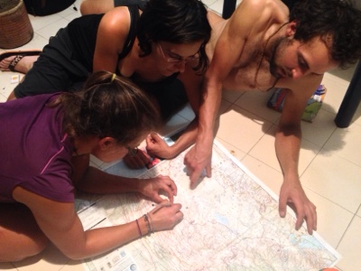
One of our favorite pastimes, looking at maps!

Check out this midnight snack!
So many thanks to everyone for delicious food and interesting stories and advice.
Route and Area Notes
- Girardot to Neiva: paved, big shoulder the whole way. Not too much traffic but increasing near cities.
- Desierto de Tatacoa: accessed from Villavieja, 4 ways to enter. 1) paved overland route from Neiva, 2) rough (but, people told us, not too rough, whatever that means - we didn't take it) overland route from Pueblo Nuevo, ~30km north of Aipe, 3) by ferry from Pata, about 20km north of Aipe, 4) ferry from Aipe. See Tam's detailed notes above for directions to the river from Aipe. The motocanoa was COP$3000 per person, and I think it's just one guy going back and forth, so ask around to see if he's shuttling people. If not, Pata may be a better option. The road to/from Neiva is a great ride, no traffic (except right next to the city) and good road condition. No shade, either, so go early.
- The observatory in the desert is about 6km east of Villavieja. The pavement ends there. The observatory is closed on the weekends, apparently. Just after are a number of posaderas and restaurants, and about 7km past those is another natural attraction, Los Hoyos, which is apparently some natural pools. Saturno, one of the first few little places on the left after the observatory, rents its pool for COP$4000 per person for the day. It and all the other places have zonas de camping, but we just wild camped.


