
Thursday, June 26, 2014
Warmth On A Cold Day, June 25, 2014
We wake up around 8:00, but only to put the fly on the tent because it has started to rain. It's around 12:00 when we actually roll out. Just two miles down the road is the small town of Nenana, which apparently means "a good place to camp between the rivers." It's situated between the Nenana and Tanana rivers (both flooded). The town is famous for its Ice Classic, a guessing game started back in 1917 where people would predict the date and time the ice goes out on the river. Back then it was $1 a guess; now it's $2.30, and you can win thousands of dollars for guessing right. The small visitor's center seems to exist primarily for the purpose of selling these tickets. Outside the visitor's center is a giant replica of the tripod that is placed on the river with a clock to mark the exact time the ice goes out. We don't spend long in Nenana, and after a short stop at the local gas station to fill up on water, we're riding out of town. The road is gloriously flat and paved, but it's cold, raining hard, and we have a headwind. What we had expected to be an easy day turns into a struggle. Around mile 25 or so, we see a beautiful blue sign indicating food and lodging ahead. Hooray! We ride into the Clear Sky Lodge, soaked and half frozen to our bikes (yes, the name seemed a bit ironic). Here we meet some wonderful people who make us giant glasses of hot chocolate with whipped cream, and garlic bread, and don't charge us anything. They also let us use their grill to make quesadillas! The warm food is amazing and rejuvenates us.
A few miles down the road, we reach a construction zone and meet a flagger named Ray, who tells us we must ride across in the pilot car. Ray is super friendly and lets us play with his husky puppy while we wait. The puppy is incredibly adorable, and getting to play with her makes my day.
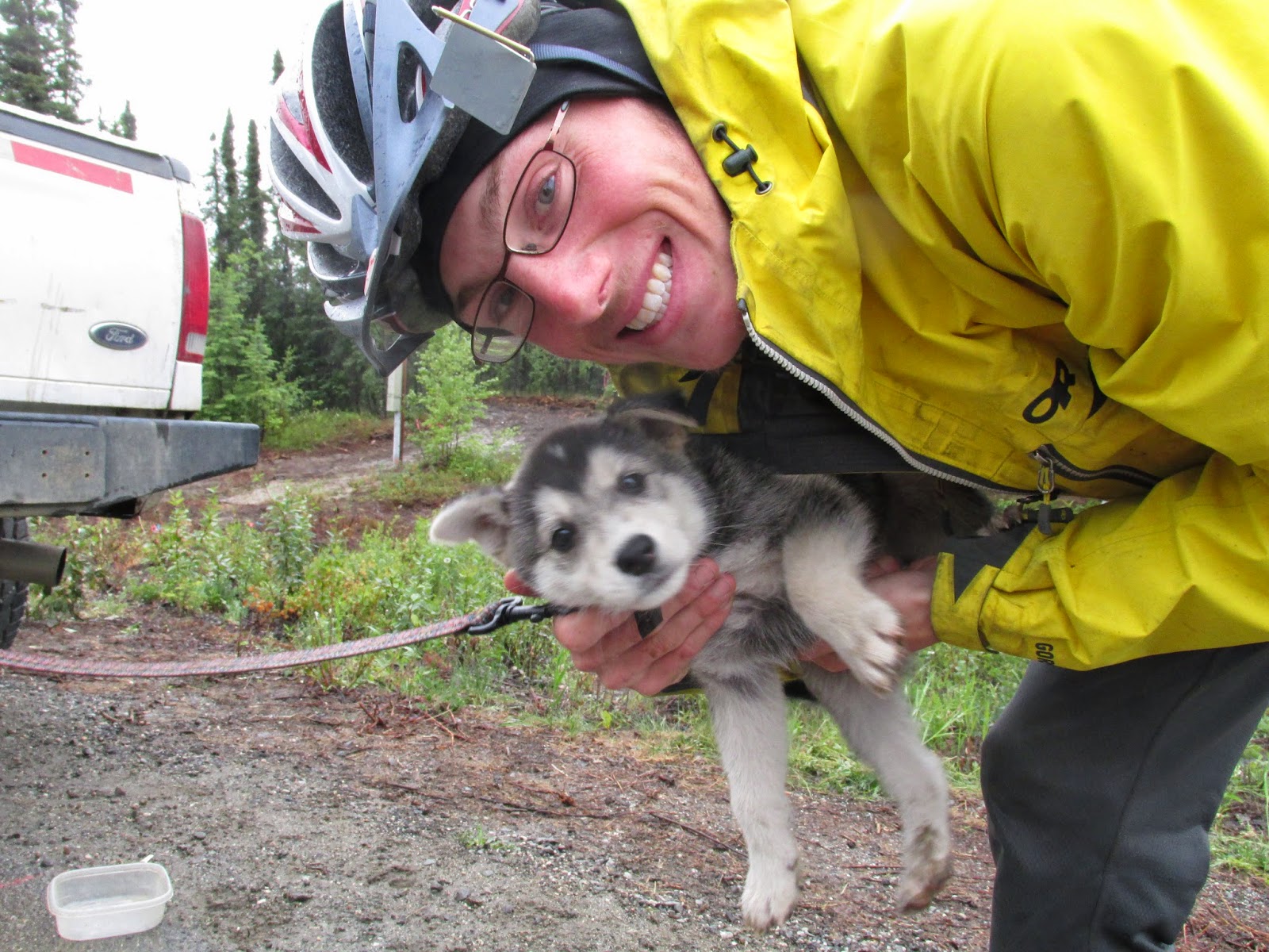
The lady driving the pilot car is also quite friendly and gives us Doritos and fireball candies as we drive the two miles of construction. After our ride, the weather turns bad again. It's windy and raining hard. A few miles down the road, we reach another construction zone. No one is working on this one because of the awful weather. We start moving slowly over big chunks of gravel, giant potholes, and lots of mud. Then we meet Al, a friendly guy from Palmer towing two boats he had just gotten at an auction in Fairbanks. He stops and offers to give us a ride. Cold, wet, and not excited to ride on the crappy road, we accept. The road is in bad condition pretty much all the way to Healy, so Al gives us a lift right to the 49th State Brewery, which multiple people had told us about. I don't feel bad about getting a lift, because if the construction crews had been working, we wouldn't have been allowed to ride that stretch anyway. Plus, this trip is supposed to be fun, and sometimes it's more fun to hang out with a nice guy in a warm truck than bike on a road filled with flooded and muddy potholes.
At the 49th State Brewery, the hostess immediately takes us inside to a pair of seats on the edge of a warm fire. It's absolutely delightful. The brewery looks like it was once a warehouse, and now it is wonderfully decorated with typical Alaskan things: a moose head on the wall, a large taxidermied grizzly bear with a cowgirl riding it, beer bottles, and wooden tables crammed with people. It's nice to be inside such a warm and happy place. We have drinks and an amazing quinoa/black bean burger, a salad with balsamic vinaigrette, and a triple chocolate mousse cake. Alright, dinner was a bit of a splurge, but I think it was worth it.. If you're ever in the area, we highly recommend both drinks and food found at this brewery. We're not much of beer drinkers, but we highly enjoyed our Solstice IPA. Afterwards, we walk outside to check out the bus from the movie Into the Wild. Since we've both seen the movie and read the book, it was very interesting to see the bus that was used, as well as see some of Chris' original journals and pictures. Reluctant to go back into the neverending freezing rain, we pay $4 to stay at the nextdoor campground. It's still raining, and weirdly, it's getting dark out.

A few miles down the road, we reach a construction zone and meet a flagger named Ray, who tells us we must ride across in the pilot car. Ray is super friendly and lets us play with his husky puppy while we wait. The puppy is incredibly adorable, and getting to play with her makes my day.
The lady driving the pilot car is also quite friendly and gives us Doritos and fireball candies as we drive the two miles of construction. After our ride, the weather turns bad again. It's windy and raining hard. A few miles down the road, we reach another construction zone. No one is working on this one because of the awful weather. We start moving slowly over big chunks of gravel, giant potholes, and lots of mud. Then we meet Al, a friendly guy from Palmer towing two boats he had just gotten at an auction in Fairbanks. He stops and offers to give us a ride. Cold, wet, and not excited to ride on the crappy road, we accept. The road is in bad condition pretty much all the way to Healy, so Al gives us a lift right to the 49th State Brewery, which multiple people had told us about. I don't feel bad about getting a lift, because if the construction crews had been working, we wouldn't have been allowed to ride that stretch anyway. Plus, this trip is supposed to be fun, and sometimes it's more fun to hang out with a nice guy in a warm truck than bike on a road filled with flooded and muddy potholes.
At the 49th State Brewery, the hostess immediately takes us inside to a pair of seats on the edge of a warm fire. It's absolutely delightful. The brewery looks like it was once a warehouse, and now it is wonderfully decorated with typical Alaskan things: a moose head on the wall, a large taxidermied grizzly bear with a cowgirl riding it, beer bottles, and wooden tables crammed with people. It's nice to be inside such a warm and happy place. We have drinks and an amazing quinoa/black bean burger, a salad with balsamic vinaigrette, and a triple chocolate mousse cake. Alright, dinner was a bit of a splurge, but I think it was worth it.. If you're ever in the area, we highly recommend both drinks and food found at this brewery. We're not much of beer drinkers, but we highly enjoyed our Solstice IPA. Afterwards, we walk outside to check out the bus from the movie Into the Wild. Since we've both seen the movie and read the book, it was very interesting to see the bus that was used, as well as see some of Chris' original journals and pictures. Reluctant to go back into the neverending freezing rain, we pay $4 to stay at the nextdoor campground. It's still raining, and weirdly, it's getting dark out.
On the Road Again, June 24, 2014
As hard as it was to leave Anna and Andrew's place for good, we had to get back on the road. So we said our goodbyes, packed up, and headed to the supermarket to get some food. Even though the bike to our next destination, Denali, would only take two days, we bought food for seven days to avoid paying higher prices near the park entrance. Thanks to the unexpectedly expansive bulk section at Fred Meyer, all of it came to only $76! We were pleasantly surprised; that's just over $5 per person per day, and we eat a lot. I've always had an appetite, but now I'm pretty much always hungry, even after finishing a significant meal. In this respect, I like bike touring much more than backpacking; I can carry more food! We realized while at the supermarket around 1 pm that our nourishment for the day had consisted of oatmeal and an Emergen-C packet (thank you Lisa and Oreo!). It's never a good idea to shop on an empty stomach, so we settled on the most yummy and economic solution: blueberry muffins. 520 calories per dollar, oh yeah. Tam didn't want one of hers, and I very much enjoyed my three. Since we'll be passing more towns now, we're going to supplement our regular food with fruits and veggies whenever we have a chance. Many thanks to Andie for sending dried mango and that fruit and nut mix; they are delicious!
We had been warned by some folks in Fairbanks about the hilly road to Nenana, about 50 miles from Fairbanks, so we were expecting a tough ride. The worst, they said, was the hill out of Ester, just out of town. But when we reached that hill, and all the others, we realized that the hills on the Dalton Highway had prepared us well. Yes, the hill from Ester was long, but it was not continuous, nor all that steep, nor gravel, nor was it followed by twenty more just like it. Moreover, the weather was perfect. Low 60s, slightly breezy, and no mosquitoes! We had the time of our lives in shorts and t-shirts. Upon arrival at the Tanana River (we found the site Andrew and John recommended - thanks guys), we built a small fire to keep the bugs away, had a great dinner and dessert, and set up the tent, folding the rain fly up off the foot so we could see the river. As I write this, the midnight sun is turning the light amber, and a beaver is swimming by just a few feet away and slapping its tail at us. 'Tis a fine night to be in a tent on a riverbank in Alaska.

We had been warned by some folks in Fairbanks about the hilly road to Nenana, about 50 miles from Fairbanks, so we were expecting a tough ride. The worst, they said, was the hill out of Ester, just out of town. But when we reached that hill, and all the others, we realized that the hills on the Dalton Highway had prepared us well. Yes, the hill from Ester was long, but it was not continuous, nor all that steep, nor gravel, nor was it followed by twenty more just like it. Moreover, the weather was perfect. Low 60s, slightly breezy, and no mosquitoes! We had the time of our lives in shorts and t-shirts. Upon arrival at the Tanana River (we found the site Andrew and John recommended - thanks guys), we built a small fire to keep the bugs away, had a great dinner and dessert, and set up the tent, folding the rain fly up off the foot so we could see the river. As I write this, the midnight sun is turning the light amber, and a beaver is swimming by just a few feet away and slapping its tail at us. 'Tis a fine night to be in a tent on a riverbank in Alaska.
 |
| taken through the tent's mesh |
Monday, June 23, 2014
Fairbanks, June 21st-23rd, 2014
We've been in Fairbanks the past two days and it's been a wonderful experience. Although initially the many roads, restaurants and traffic lights were a bit of a culture shock, we've adjusted quickly and have been tremendously enjoying ourselves. We've had a chance to explore the beautifully done Visitor and Cultural center, bike alongside the midnight sun run, and visit the solstice fair in downtown Fairbanks. We've also been able to do personal errands and update all this on the blog.
Most importantly, we have met some incredible people, students and technicians at the university, who have taken us in, spent hours helping us clean and fix our bikes, stuffed us with delicious food (best blueberry pancakes you can ever imagine) and given us a comfy bed to sleep in. It's not possible to thank Andrew and Anna enough for everything they've done for us. Much thanks also to Lily for welcoming us into her circle of friends and to everyone else for being so friendly and helpful.
Most importantly, we have met some incredible people, students and technicians at the university, who have taken us in, spent hours helping us clean and fix our bikes, stuffed us with delicious food (best blueberry pancakes you can ever imagine) and given us a comfy bed to sleep in. It's not possible to thank Andrew and Anna enough for everything they've done for us. Much thanks also to Lily for welcoming us into her circle of friends and to everyone else for being so friendly and helpful.
 |
| Fairbanks |
We Love You Elliot Highway, June 20th 2014
We've camped just off the road on a pipeline service road. At 7:00AM we are jolted awake by trucks zooming by. A guy stops to tell us that bigger trucks will be coming soon, so we pack up our gear as fast as we can. It's just in time; as we roll out, a giant truck rolls in. Figured that we would choose to camp on the only service road that they are actually using. Tired but alert for the moment, we're excited to start biking on the paved Elliot Highway. The morning ride has ups and downs but all are more gradual than the awful hills of the Dalton. More passenger cars start appearing among the trucks. We make it 20 miles before we have to pull off the road and take a break. We end up sleeping for 5 hours, exhausted from the night before. When it starts raining through the mesh of our tent we pack up and keep riding. Just down the road we find a little shop with snacks and tourist stuff. It seems to be the only establishment in a small 'town' called Joy.
The people working there are very friendly and tell us all about other travelers that have come through. As we eat giant double chocolate chip muffins, our friends Daniel, Katrien and Manu roll in! They tell us how they almost hit a giant black bear who was crossing the road as they were coming downhill! We stay and talk for awhile, and learn that 43 miles down the road is a truck stop with amazing pie. We decide to keep biking and try to get there.
What follows is what can only be considered a fairytale ride. The road is paved with dense forests on either side. It's warm and breezy enough to keep the mosquitoes away. The rain is gone; only a few white clouds dot the sky. As we ride from 8:00PM-12:00AM, we experience the full beauty of the sunset and the midnight sun. At first the road brings us up and down, but the grades are far more gradual than the Dalton and we make good time. High on sugar and loving the beautiful weather, we feel like we're flying. Then the road starts going downhill and we coast for mile after easy mile. The last 3 miles is straight uphill, but at the end we find Hilltop truckstop where we are able to fill our water bottles and pitch our tent. We're 16 miles outside of Fairbanks and tomorrow is the solstice!
 |
| the wonderful store in Joy |
What follows is what can only be considered a fairytale ride. The road is paved with dense forests on either side. It's warm and breezy enough to keep the mosquitoes away. The rain is gone; only a few white clouds dot the sky. As we ride from 8:00PM-12:00AM, we experience the full beauty of the sunset and the midnight sun. At first the road brings us up and down, but the grades are far more gradual than the Dalton and we make good time. High on sugar and loving the beautiful weather, we feel like we're flying. Then the road starts going downhill and we coast for mile after easy mile. The last 3 miles is straight uphill, but at the end we find Hilltop truckstop where we are able to fill our water bottles and pitch our tent. We're 16 miles outside of Fairbanks and tomorrow is the solstice!
End of the Dalton, June 19th 2014
 |
| very sticky mud. Everywhere. |
 |
| riding into some storm clouds on the pavement... before the gravel |
 |
| the Dalton Highway |
 |
| American Three-toed Woodpecker |
On the Dalton Highway...Still, June 18th 2014
Don't get me wrong, I like the Dalton. I like its remoteness. I like its scenery. It seems like a trail at times, with cyclists at all different points, always a chance to meet interesting people! But today was rough. Yesterday's very steep ups and downs continued today and were supplemented by rain and, subsequently, mud. Very sticky, grainy mud, due at least in part to the stuff that's put on the road to keep the dust down. It wore away at our brake pads and rims, and Tam's chain got stuck and somehow pulled her derailleur into her rear spokes; she was able to stop and extract it before any huge damage was done, but unfortunately, the part of the bike frame that the derailleur attaches to was bent.
We got it working, but Tam now cannot shift her rear derailleur without risk of entangling it in the spokes and wrecking the wheel. So tomorrow and the next day might be slow due to Tam having to walk up the frequent, very steep sections, but, as I said to Tam earlier when she was worried about taking an extra day to get to Fairbanks, it's hard to get slower than the 3 mph we've been doing up these hills. We're trying to get to Fairbanks for the summer solstice, which gives us two days to go the remaining 134 miles. 50 miles or so until pavement, so I hope the rain stops or tomorrow will be a slog.
On the plus side, we had the most fantastic dinner tonight at the Yukon River Camp.
We weren't planning on having a full dinner, just something small, but while we were trying to decide on a side of fries or a salad with our veggie burger, our waitress, Ashley, to whom we had talked briefly about our adventure, decided to bring us both one of each! On the house! We were astounded and enjoyed every bite of the warm, flavorful food. Our post-dinner plans involved eating dinner again, this time our regular (and always delicious) couscous, soybeans, and olive oil, so when Ashley came by asking whether we wanted some pie, I said thanks but that it probably wasn't in the cards. Then she listed the options: blueberry, cherry, rhubarb, and something else. They sounded so good I just had to ask how much a slice was. She thought for a minute and smiled. "On the house. Now which one?" Tam and I quickly discussed our preferences. "I'm thinking blueberry," she said. "I'm thinking cherry," I said. Then Ashley said, "I'm thinking one of each!" and walked away. We sat there laughing and again enjoyed every mouthwatering bite of our pies, a la mode of course. Ashley likes adventure and wants to encourage that kind of thing, she said. I am certainly encouraged, full, and content with a great finish to a long day.
 |
| bent derailleur hanger |
On the plus side, we had the most fantastic dinner tonight at the Yukon River Camp.
 |
| Yukon River - almost done with the Dalton! photo credit: http://home.earthlink.net/~studio1photo/dalton.htm |
Mountains and Mosquitoes, June 17th 2014
After a rough night of sleeping on uncomfortable rocks and waking up to the sound of trucks that I thought were bears, I wake up and go talk to the other cyclists camped by us. One is Daniel from Sweden, also planning on going south to Argentina, and the other two are Katrien and Manu, from Belgium, planning on going somewhere in Mexico. All three are very friendly. The leave earlier than we do, but we're sure that we will see them down the road. The biking starts off with small but steep ups and downs, but slowly these become big mountains and valleys. The mosquitoes are out of control. Going slow on the uphill, I am completely mobbed. Any section of exposed skin is destroyed by bug bites. My ankles and hands swell up with the bites and feel like they're on fire. The first big hill is called Gobblers Nob, the second is the Beaver Slide, and the third is Finger Mountain.
We see our friends at the top of the Beaver Slide, stopping to camp for the night. Thankfully, near the end of our day it turns windy so most of the mosquitoes go away. We pitch our tent at the top of Finger Mountain on the edge of a beautiful nature trail.
 |
| Beaver Slide up ahead. Those dots ahead in the road are Manu, Katrien, and Daniel |
 |
| It has a large, protruding rock that looks like a finger |
A Bear-y Exciting Encounter, June 16th 2014
We wake up early to bright sunshine and people visiting Clutch's museum. After projects and more stories we leave for Coldfoot. At Coldfoot we get our food package and order a salad for some nutrition. Then we're off biking on the Dalton again, heading towards Fairbanks. On the way we meet a friendly guy going to Deadhorse who is from Slovenia! The road is pretty hilly and our legs are hurting, so we stop early.
What follows is the bear episode as written by Danny:
We were camped earlier tonight at the convergence of two roads, the one coming from the main road about a quarter mile away, and the rough service road that parallels the ever-present Trans-Alaska Pipeline. Other than the open area in which we placed our tent, thick brush surrounded us. At one point before bed, while Tam was writing the day's summary in her journal, she turned to me and said, "Ssh! Listen." I was reading, so I wasn't making too much of a ruckus as it was, but I cocked my head and listened. I heard the hum of the mosquitoes and nothing else.
"Hmm," she said, "I thought I heard something." We continued doing what we had been doing. Tam finished writing and was about to read it to me when I asked her to hold on a second. I thought I had heard something, something small. Probably wasn't anything. We both lay still for a moment, and this time we heard definite sounds from outside. Some breathing, some panting, something outside the tent. Something big. Tam turned to me, her voice quavering, "What do we do?" I thought back to my previous run-ins with bears and to our conversations. We had discussed this exact situation a few weeks before. "Well," I said, trying not to display how scared I felt, "we should talk. Loud enough that it, bear or moose or caribou or whatever, knows that we are here, but not so loud that we scare it." So we talked. We dictated our every thought and every action for what seemed like ten minutes. Most importantly, we discussed our next step. "Should we go out there? Maybe it's just a curious moose." We listened again. Nothing except the mosquitoes and the pounding of our hearts. We decided to go out together and investigate. We pulled on our shoes and slowly unzipped the vestibule. I was expecting to see whatever it was right there, but we looked around and saw nothing. We debated packing up and moving; if only we knew what this animal had been!
We decided to pack up and move anyway, and as we were doing that, I looked south, down the pipeline. "Uhh, Tam?" "Yeah?" "There's a grizzly bear over there." "What?" She hadn't heard me clearly. "There's a bear over there." We looked together at a bear, unmistakably grizzly, standing in the open by the pipeline about 100 yards away. It was a smaller bear as grizzlies go, maybe 350 pounds, with a beautiful light brown coat darkening to black on its rump. It started to walk towards us. My heart was racing. Even a small grizzly bear is not something you want to mess with. We talked quickly about what to do. This, again, was a situation we had discussed previously. It's extremely rare that bears attack humans unless surprised or provoked, but we looked around anyway for things to defend ourselves with if need be. We didn't have bear spray or a gun, as common sense is always more effective (and they hadn't had any at the Deadhorse General Store), but I had carried a strong stick for the past five days; what I would give to have that now! There were some large branches under the pipeline, maybe twenty feet away, but that was too far. I picked up the woefully minuscule twig at my feet. "Hey!" I yelled at the bear, waving my arms. "Look, I have a stick!" Tam started waving her arms and yelling at it. "Yeah, Danny's got a stick! We're humans! We're big! Go away!" The bear was unfazed. It started walking faster towards us, then broke into a trot. Against all impulse to run (NEVER run from a bear), we stepped towards it, yelling louder and gesticulating more frantically. "No! Bad bear!" Tam put on her bike helmet and I followed suit, feeling like Paris about to battle Hector. Still, we knew that bears often charge falsely just to see what kind of animal they're dealing with. Sometimes they're just curious. I certainly would be curious, had I lived my whole life in the woods and just stumbled upon two bipedal organisms clad in bright red and yellow. Anyway, this one stopped its approach about 50 feet away behind a shrub, and stood on its hind legs to get a better look at us. We continued yelling like idiots, laughing nervously while waving our useless weapons and shouting whatever we could think of. "We're large!" "And in charge!" "I have bug spray, bear!" "You definitely don't want that in your eyes!" After a long pause, it turned around and walked away, pausing to look back every few steps. Phew, I thought. "Let's get out of here," said Tam. We continued packing our things, definitely more hastily than before, while continuing to yell, and I glimpsed the bear in the brush, closer than it had been before. It had circled around to our side. Before I had been anxious, but now I was downright scared. What may have been curiosity now seemed to be bordering on predatory stalking. We must have set a record for fastest camp breakdown, and then we walked our half-packed bikes to the road, yelling and glancing over our shoulders. We didn't see it again; who knows whether it ran off or followed us. After riding a few miles up the road, we pitched our tent next to some other cyclists on the banks of a large river.
Unfortunately, in the rush of trying to get a large bear to go away, I didn't get any pictures. It looked something like this:

What follows is the bear episode as written by Danny:
We were camped earlier tonight at the convergence of two roads, the one coming from the main road about a quarter mile away, and the rough service road that parallels the ever-present Trans-Alaska Pipeline. Other than the open area in which we placed our tent, thick brush surrounded us. At one point before bed, while Tam was writing the day's summary in her journal, she turned to me and said, "Ssh! Listen." I was reading, so I wasn't making too much of a ruckus as it was, but I cocked my head and listened. I heard the hum of the mosquitoes and nothing else.
 |
| the hum of the mosquitoes is sometimes a roar |
We decided to pack up and move anyway, and as we were doing that, I looked south, down the pipeline. "Uhh, Tam?" "Yeah?" "There's a grizzly bear over there." "What?" She hadn't heard me clearly. "There's a bear over there." We looked together at a bear, unmistakably grizzly, standing in the open by the pipeline about 100 yards away. It was a smaller bear as grizzlies go, maybe 350 pounds, with a beautiful light brown coat darkening to black on its rump. It started to walk towards us. My heart was racing. Even a small grizzly bear is not something you want to mess with. We talked quickly about what to do. This, again, was a situation we had discussed previously. It's extremely rare that bears attack humans unless surprised or provoked, but we looked around anyway for things to defend ourselves with if need be. We didn't have bear spray or a gun, as common sense is always more effective (and they hadn't had any at the Deadhorse General Store), but I had carried a strong stick for the past five days; what I would give to have that now! There were some large branches under the pipeline, maybe twenty feet away, but that was too far. I picked up the woefully minuscule twig at my feet. "Hey!" I yelled at the bear, waving my arms. "Look, I have a stick!" Tam started waving her arms and yelling at it. "Yeah, Danny's got a stick! We're humans! We're big! Go away!" The bear was unfazed. It started walking faster towards us, then broke into a trot. Against all impulse to run (NEVER run from a bear), we stepped towards it, yelling louder and gesticulating more frantically. "No! Bad bear!" Tam put on her bike helmet and I followed suit, feeling like Paris about to battle Hector. Still, we knew that bears often charge falsely just to see what kind of animal they're dealing with. Sometimes they're just curious. I certainly would be curious, had I lived my whole life in the woods and just stumbled upon two bipedal organisms clad in bright red and yellow. Anyway, this one stopped its approach about 50 feet away behind a shrub, and stood on its hind legs to get a better look at us. We continued yelling like idiots, laughing nervously while waving our useless weapons and shouting whatever we could think of. "We're large!" "And in charge!" "I have bug spray, bear!" "You definitely don't want that in your eyes!" After a long pause, it turned around and walked away, pausing to look back every few steps. Phew, I thought. "Let's get out of here," said Tam. We continued packing our things, definitely more hastily than before, while continuing to yell, and I glimpsed the bear in the brush, closer than it had been before. It had circled around to our side. Before I had been anxious, but now I was downright scared. What may have been curiosity now seemed to be bordering on predatory stalking. We must have set a record for fastest camp breakdown, and then we walked our half-packed bikes to the road, yelling and glancing over our shoulders. We didn't see it again; who knows whether it ran off or followed us. After riding a few miles up the road, we pitched our tent next to some other cyclists on the banks of a large river.
Unfortunately, in the rush of trying to get a large bear to go away, I didn't get any pictures. It looked something like this:
Wiseman, June 15th 2014
We wake up to sunshine and a light breeze on top of Vermont Dome. We pack our stuff and head down the saddle. It's open ground and smooth hiking until we get to the valley of Acme Creek. Then it's talking, singing, and bushwacking through trees and brush until we fall out on an old winter trail next to the small mining town of Nolan. It's easy hiking down the flat-downhill road to Wiseman.
 When we arrive, we visit the Boreal Lodge- Heidi's place- to get some snacks. The main store is a large open room with artful decorations and all sorts of handmade, home-produced things for sale. We buy ice cream bars and some jam made from wild low-bush cranberries (lingonberries) just canned yesterday! We talk to Heidi and her lovely shop assistant about hiking, exploring and collecting the local rocks to make jewelry. I'm given a beautiful necklace with a quartz stone which I have been wearing ever since. The generosity of these people is tremendous.
Heading out of Wiseman we meet Clutch, an older gentleman with a fantastic fluffy white beard. He offers to give us tent space for a night and a ride to Coldfoot in the morning in exchange for help with a few projects. We gladly accept. We end up setting up a large tent with tables and chairs underneath, setting up cots, and shoveling sand to make another level area for a tent that we had all the parts to but no directions for how to set up. This was all to get ready for some visitors and parties Clutch is planning for the summer. In exchange, not only did we get our tent space and a ride, we had showers, got to do laundry, and had amazing sourdough pancakes. Most importantly, we got a lot of stories. The stories started in Clutch's little museum, a small log cabin with tons of artifacts from the mining days inside. "If you can't grow it, mine it." Clutch loves geology and history, and even though neither of these are my favorite subjects, his passion and excitement about sharing made me excited as well. He tells us about local rocks, how he and his grandma are both in the ice hockey hall of fame in Fairbanks, about the Zamboni he built with paint that changes colors, and a ridiculous reality TV show he was on. The stories are too many to write here, but if you're interested, I can tell you more someday.
 |
| Us with Clutch |
 |
| Clutch's yard around 1 am |
 |
| Clutch's museum |
Vermont Dome, June 14th 2014
We wake up to a bit of rain, but it soon goes away and the day becomes sunny and warm. This isn't great because it means that we both overheat in our rain gear, which we can't take off due to the hordes of mosquitoes. We start off the day hiking through a bit of brush, but soon find a ridge where we can get a good line of sight of where we'll be going. Our path brings us up a ridge, down a steep slope into a valley with a small creek, up a steep slope on the opposite side, around and up another ridge, then up and up and up. We encounter some tussocks, but they are small and not bad to hike over. We stop for lunch on the last ridge before the final ascent to Vermont Dome.
Some treasures of the trail included:
-A white-crowned sparrow nest with 5 blue-brown speckled eggs.
 -A random metal pail in the brush. Not sure where it came from.
-A rainbow building its way up out of the river valley opposite us.
-A big hunk of quartzite, perfectly cleaved and translucent.

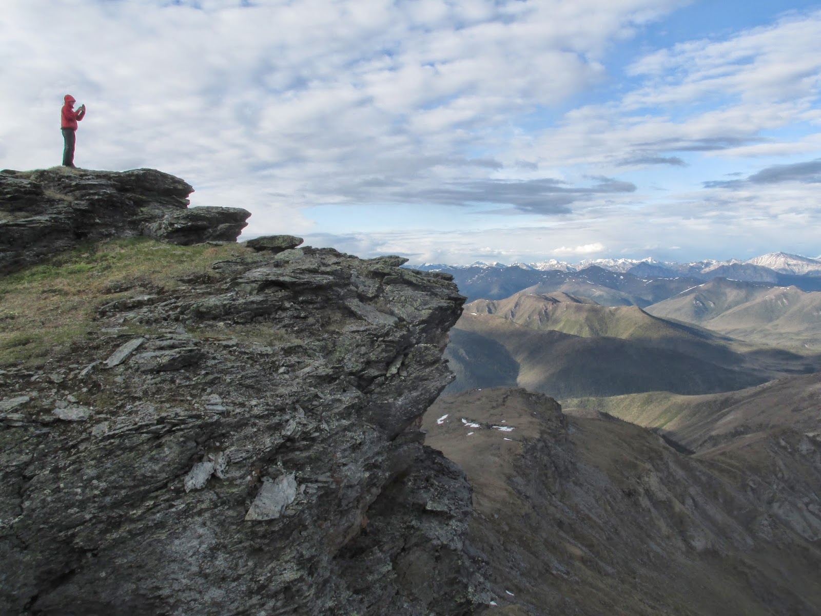
My legs are aching when we reach the summit of Vermont dome, but it is well worth the view. In every direction are snow capped, enormous craggy peaks. Below these peaks are smaller mountains, artfully sculpted and carved by glaciers long ago. Then far below those are the rivers, braiding their way through the landscape, still carving and shaping it today. I don't know where to look because it is all so amazing. We have dinner and watch the sun come out from behind the clouds to illuminate the mountain ridges. In the saddle of the mountain we set up the tent and fall asleep under the midnight sun.


 |
| sidehilling in rain gear. Vermont Dome in background |
-A white-crowned sparrow nest with 5 blue-brown speckled eggs.
-A rainbow building its way up out of the river valley opposite us.
-A big hunk of quartzite, perfectly cleaved and translucent.
My legs are aching when we reach the summit of Vermont dome, but it is well worth the view. In every direction are snow capped, enormous craggy peaks. Below these peaks are smaller mountains, artfully sculpted and carved by glaciers long ago. Then far below those are the rivers, braiding their way through the landscape, still carving and shaping it today. I don't know where to look because it is all so amazing. We have dinner and watch the sun come out from behind the clouds to illuminate the mountain ridges. In the saddle of the mountain we set up the tent and fall asleep under the midnight sun.
Mosquitos and Tussocks, June 13th 2014
After spending some time around camp reading and taking advantage of the nice weather by Glacier River, we each took very quick, frigid baths in the river then continued on our way. Hiking by this large river was great! We had to cross it a few times, which, again, reminded us that we were in the Arctic, but hiking on gravel and mud was easy and picturesque. The scene was classic Alaska: a strong, braided river with snowy mountains above.
 After the ease and beauty of following the river, we picked a smaller one, Washington Creek, to follow east into the hills. Unfortunately, this one would not be so simple. Getting there required navigating a mile or so of marshy tussocks sometimes accompanied by thick brush. We breathed a sigh of relief upon reaching the creek, but the constant crossings chilled our feet to numbness, and the thick brush on the steep banks slowed our pace considerably and tore at our mosquito nets. Eventually we just headed straight up the hill and pitched the tent, exhausted. We ate dinner in the tent, no rain fly on, because the mosquitoes basically prohibited eating outside. I made the mistake yesterday of trying to eat peanut butter while mosquitoes swirled around me; I gave up after fishing eight of them out of the jar and lid. Through the tent's mesh we were treated to a glorious 1 am northern sunset/sunrise, and the alpenglow on the big, snowy mountains to the south took my breath away. The knowledge that at every moment we are earning our right to be in this rugged wilderness makes everything around us, the sunsets and mountains and the grizzlies, that much more significant. As the toil of maneuvering hills and tussocks sets in my muscles, all else that is here remains huge in my mind. The unclimbed mountains, the colors of the tundra, all of it. My mind, however, is not that big, so my camera will hopefully be able to pick up where it fails.

Gates of the Arctic. June 12th 2014
 |
| We went out of Wiseman, in the southeast corner of the park. Photo credit: http://jukebox.uaf.edu/site7/project/59 |
 |
| Old mining road and winter trail just inside the park. Too marshy for us. |
Normally the sphagnum moss springs right back up after you step on it, but 12 hours under a tent is a different story. I hope we didn't kill a 5x8 patch of tundra; we will do our best in the future to camp on gravel bars. That wasn't an option last night, but tonight we are camped on firm mud in the middle of the aptly named Glacier River. Another soft bed, and this time without mosquitoes! We got here, maybe 7or 8 miles away, by tromping through miles of tussocks. Tussocks are raised patches of vegetation perhaps 6 to 24 inches high and similarly wide.
 |
| tussocks! Photo credit: http://backpackinglight.typepad.com/photos/arctic_1000/imgp1253800.html |
 |
| camped on the Glacier River |
Coldfoot, June 11th 2014
We get up around 10:00AM to be greeted with cold wind and rain. The frigid headwind makes biking unpleasant, but the forest on either side of us is lush and glistening with the rain. The streams are gushing happily with the fresh rainwater and the mountains loom mysteriously, shrouded by clouds. In some ways it is still a beautiful morning. It's only 13 miles to Coldfoot, where we find a mud pit full of trucks and ramshackle buildings. Luckily, one of these buildings is the lodge which is actually quite nice. We walk out of the cold into a small, cozy room lit with Christmas lights and
painted with murals of winter scenes. We meet Keith at a table, just sitting down for breakfast. Then proceeds a delicious breakfast of large buttermilk pancakes, the rest of Keith's toast and hash browns, as well as large white chocolate cherry cookies. We have a wonderful breakfast, exchanging stories and math problems. After the meal, we pick up our food packages and talk to another biker who has just rolled in named Nathan. He has an awesome lightweight set-up on his bike that I'm definitely
going to keep in mind for future travels. After repacking, we say goodbye and head across the street to the Visitor's center, which is beautifully designed. It looks completely new and has a theater,
interactive displays, and tons of information. Here we meet Heidi, an incredible lady who grew up in Wiseman and now runs her own business there as well as working for the National Park Service. We spend all afternoon looking at large laminated maps, planning where to hike and talking to her about everything from winters in the far north to pipeline construction. At 8:00PM we go to the daily presentation in the theater. Tonight it is about the first people in this region who came looking for gold. The presentation is very well done. We learn how big steamer ships froze solid in the river their first year, and many got 'cold feet' and turned back, traveling overland to go back south. The few that stayed developed a strong community. To get through tough times they danced and played music, and they had to learn how to do everything themselves. The gold explorers also met the natives. Some assimilated into the community and helped it thrive with their local knowledge. Unfortunately many also got sick from diseases the pioneers brought with them.
After the presentation we meet Mel and Kelley, world travelers. They generously offer to drive us a few miles up the road to the starting point of our backpacking trip. We leave our bikes locked at the visitor's center, grab our packs and go. They bring us on a small tour of Wiseman and show us a small church built in honor of a native woman who used to live in the area. The outside is a bit ramshackle, but inside it is carefully, and beautifully decorated, warm and cozy. A small gem in the forest. Then they take us up the Nolan road (a mining road) and drop us off in a valley amid tremendous mountains. (Thanks again for the ride!)
We hike along the road for a while finding fresh bear tracks and scat. After a few miles we walk down through some brush and find ourselves in the land of the tussocks. We quickly discover why they are called ankle-breakers. But I love them. The diversity of life and colors found in this vegetation remind me of the underside of tidal rocks I researched on the Maine coast. It's late and cold so we eat dinner and set up the tent.
 |
| Coldfoot restaurant. photo credit: http://www.tripadvisor.com |
 |
| Nathan is an incredible photographer - check out his website at www.nathanlanephotography.com |
 |
| the beautiful Arctic Interagency Visitor Center |
After the presentation we meet Mel and Kelley, world travelers. They generously offer to drive us a few miles up the road to the starting point of our backpacking trip. We leave our bikes locked at the visitor's center, grab our packs and go. They bring us on a small tour of Wiseman and show us a small church built in honor of a native woman who used to live in the area. The outside is a bit ramshackle, but inside it is carefully, and beautifully decorated, warm and cozy. A small gem in the forest. Then they take us up the Nolan road (a mining road) and drop us off in a valley amid tremendous mountains. (Thanks again for the ride!)
We hike along the road for a while finding fresh bear tracks and scat. After a few miles we walk down through some brush and find ourselves in the land of the tussocks. We quickly discover why they are called ankle-breakers. But I love them. The diversity of life and colors found in this vegetation remind me of the underside of tidal rocks I researched on the Maine coast. It's late and cold so we eat dinner and set up the tent.
 |
| our tent on the tussocks |
Atigun Pass, June 10th 2014
From the time we got up this morning, our thoughts were on one thing: Atigun Pass.

It's the highest point on the Dalton Highway, at over 4,000 feet, and it marks the official entrance into the mountains. I was a little worried about it; I had seen pictures of snowstorms on the pass in July. The "Snow Removal Equipment Ahead" signs weren't encouraging, nor were all the trucks we passed coming from the pass with their windshield wipers on. But we kept on moving anyway through a rolling valley, prepared to start going up at any time. That valley eventually ended, and we saw our road ahead going up and a sign announcing the pass. It didn't look so bad, but it turned out to be pretty steep and sustained, maybe 12-14% grade on a muddy gravel road for a few miles. So it took us awhile to get up, but upon arrival at the top we agreed that, for all the hype, it wasn't so bad. We even saw a group of Dall Sheep on the way up!
We then came down out of the pass into an incredibly picturesque valley. Snowy mountains on either side framed the braided river alongside which we rode.
Spruce trees now lined the road as well, welcome friends on our journey. Interestingly, the sign marking the farthest north spruce ("please do not cut"), stands maybe 50 feet south of the farthest north tree. Global warming, or bad sign placement? I don't know. With the trees came mosquitoes, hordes of them, but we barely noticed because the road was paved for twenty miles or so! A nice surprise. 14 miles to Coldfoot tomorrow, where packages of food should await.
 |
| Tam being a sheep |
 |
| Me at the top of the pass |
 |
| It's like a picture. Seriously. |
 |
| Tam biking through the mountains on that amazing road |
 |
| photo credit: http://www.roadtripamerica.com/forum/showthread.php?30053-Heading-for-the-Horizon-2012/page7 |
Mud and Hills, June 9th 2014

 |
| Norm's "office" |
Cool Riding, June 8th 2014
 |
| Keith |
 |
| chilly! |
The low lying clouds reflect in the lakes of the tundra and seem to sandwich us and our road between them. Early on there are a few stretches of flat paved road that feel wonderful to bike on, but soon we are back to gravel.
 |
| tundra lake |
 |
| Brooks Range |
The road is no longer flat; we start climbing up hills, then winding down through flat river valleys. Our ride ends with a giant gravel hill named "Oil Spill Hill." Exhausted, we find a spot to camp by the river and drink silty water.
Subscribe to:
Posts (Atom)