1) Food and Water
Pretty much any town or city will have a grocery store, and tap water is always drinkable unless
otherwise indicated.
2) Shelter
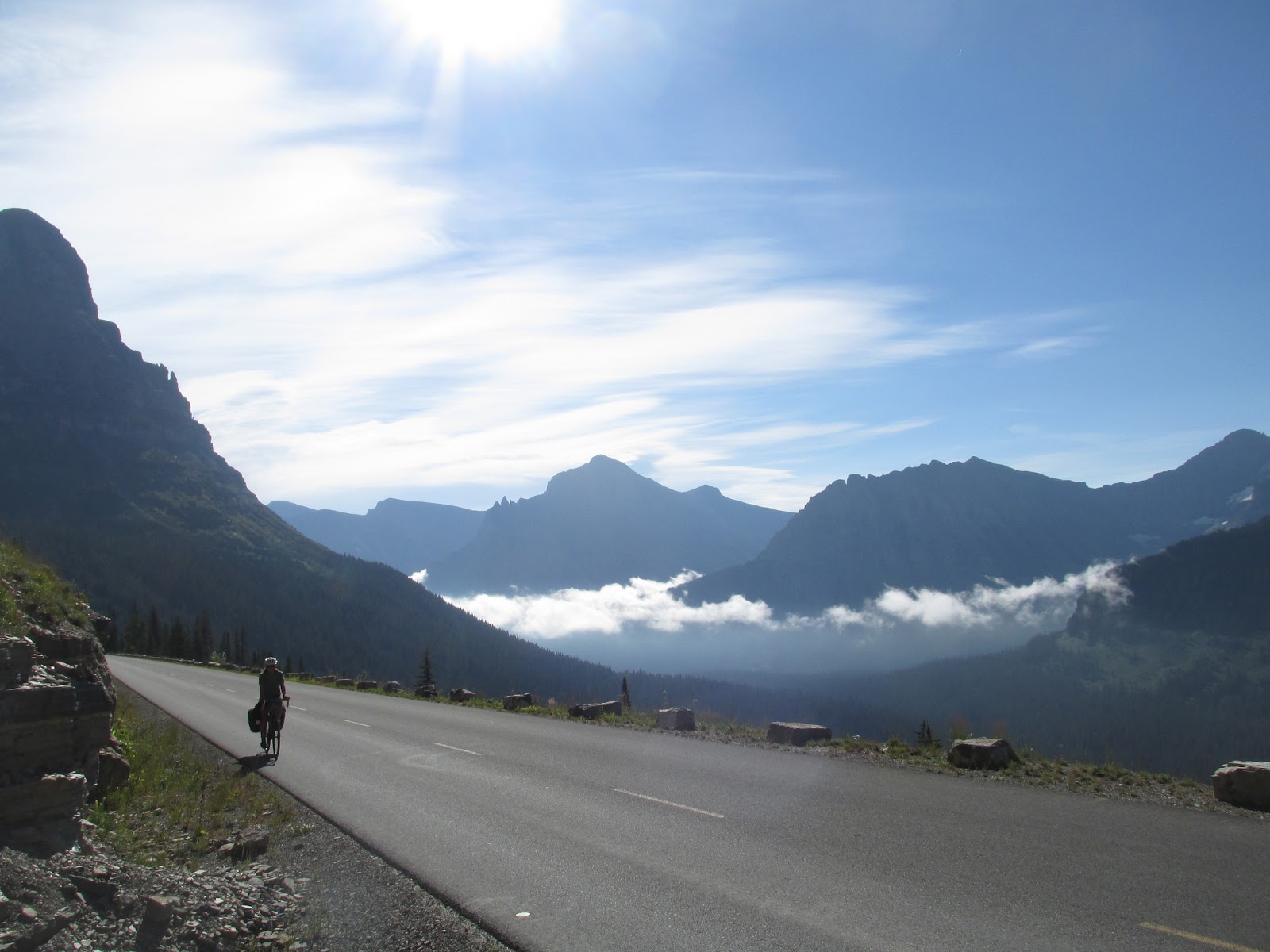
 |
| Highway 12, Idaho |
In
small towns, usually it is fine to camp in the local park. If you're looking for a bed,
there are lots of Warmshowers and Couchsurfing hosts.
Hotels are very expensive and we avoided staying in them unless someone else
was generously sponsoring us.
Most cyclists heading south follow the Pacific Coast Highway down the west coast, and a number of others follow the Great Divide Mountain Bike Route through Montana, Wyoming, Colorado, and New Mexico. We thought the ocean would
get boring after a while and took to the mountains instead, but on paved routes in California and Oregon, not the Great Divide. There are an overwhelming amount of
good road options in the U.S. Even remote back roads are often paved or have a
smooth bikeable surface. Get creative!
Our Route
Montana
Montana
We entered the U.S. at Chief Mountain, on the northeast side of Glacier National Park. Going-to-the-Sun Road through the park was super scenic, very gradual, and fairly easy. Definitely recommended. From the top of the pass, we
climbed Oberlin Peak and were rewarded with an incredible view of the
park! Also don't miss Jammer Joe's all-you-can-eat lunch buffet at Lake McDonald Lodge!
From June 15 to Labor Day, parts of the Going-to-the-Sun Road are closed to cycling between 11 am and 4 pm.
From Glacier we went to:
From June 15 to Labor Day, parts of the Going-to-the-Sun Road are closed to cycling between 11 am and 4 pm.
 |
| Tam riding the Going-to-the-Sun Road, Glacier National Park, Montana |
From Glacier we went to:
 |
| Our route through Montana, Idaho, and part of Washington |
The road through Columbia Falls to Kalispell was trafficked and sometimes without a shoulder. Not a good
biking road.
Missoula
This town is the home
of the Adventure Cycling Association; stop in to check out their museum/office/cycling heaven! The
town is super bike friendly and has a great farmer's market as well.
Idaho
Idaho
Highway 12
If you're traveling west, you'll hit Lolo Pass on the Montana-Idaho border, and almost all of scenic Highway 12 through Idaho follows rivers gradually downhill. There are two
fantastic natural hot springs along the way, Jerry Johnson (clearly signed) and Weir Creek (look for a small sign barely visible from the road). Near Lewiston the traffic picks up, but without the shoulder increasing as well. It's worth trying to
avoid the city; at least take the bike path along the river.
Washington
Washington
Walla Walla
A little farming city that is just entering the world of wine. Roads in and out are decent but trafficked near the city. In visiting Walla Walla, we just cut through the corner of Washington. If we went back we would ride through the Olympic Peninsula and the Cascades. We've heard from numerous people that these are spectacular areas.
Oregon
Oregon
The Northeast
 |
| Our route through Oregon |
Bend
Entering from Prineville was a nightmare in places, but probably exacerbated by the fact that we arrived at rush hour. Once we got into the city, Bend is an awesome outdoorsy
town. There are lots of bike paths and parks, and if you're into beer, this
place is bursting with microbreweries. For bike repairs, the folks at Sunnyside Cycles were super helpful and knowledgeable. Just to the west of
town is the beautiful Cascade Lakes Scenic Byway and the Three Sisters Wilderness, where we went backpacking. There are
no fees, and the volcanic landscape is spectacular.
Crater Lake National Park
This park, though small, touts a scenic rim road, the highest paved road in Oregon, some great trails, and an all-you-can-eat buffet at Annie Creek Restaurant on the west side. As cycling increases in popularity, the park service is doing Vehicle-Free Days on a few weekend days in September. See here for details.
Klamath Falls
Pedal by as fast as you
can. There's no shoulder for most of the approach; watch out for traffic.
California
 |
| Crater Lake sunrise from the tent |
 |
| The entrance to a cave in Lava Beds National Monument |
California
Lava Beds National
Monument
Once past Klamath Falls, traffic dies down towards Merrill, and the border crossing into California was so quiet on our little back road that there wasn't even a "Welcome to California" sign. Tule Lake is a
great place for bird watching, and Lava Beds National Monument offers superb caving. Since you're an able-bodied cycle tourist, you'll have no trouble
exploring even the advanced caves (crawling sometimes required). Just grab your bike helmet and a headlamp (with charged batteries), and go for it! We found the park staff to
be really welcoming and friendly. Definitely worth a stop!
Lassen Volcanic
National Park
Leaving Lava Beds, the
back roads we took were so quiet and free of cars that we could listen to
podcasts while riding. Once we got on the 299 at Bieber, traffic got really bad. The 299 and the 89 into Lassen were bustling with
logging truck traffic. This is the closest we've ever come to being hit by a
truck. The recent forest fires in the area probably increased the amount of logging traffic, so the road may hopefully be better in other seasons. Once in the park, riding
over the mountain pass was peaceful and beautiful. We took some time to do a
couple short hikes as well.
 |
| Our route through northern California Oregon border to Merced |
Highway 89
This road is part of a
route mapped and recommended by the Adventure Cycling Association. There are solid mountain climbs and plenty of wild scenery. However, there is often
little to no shoulder on the road and a fair amount of truck and car traffic. I
wouldn't do it again.
Lake Tahoe
We took the road along
the west side of the lake. There was a good shoulder, then a bike path for much
of the way. Friends told us that this side was safer for cycling and we found
it to be a pleasant ride.
Monitor Pass
Out of Lake Tahoe there
are several mountainous options for roads to take south. We climbed up Monitor Pass,
a steep and gusty but excellent ride. It is included in a race
called the "Death Ride," if that tells you something about the grade.
395
To ascend Tioga
Pass in Yosemite, the only access point from the east is Highway 395. Riding was okay in parts, but by the Walker River north of Bridgeport, unpredictable and extremely gusty winds started blowing us off and into the road. There was little to no shoulder and sometimes heavy traffic. After a little while riding on this road, we accepted a ride
from a passing cop, who brought us to Lee Vining, at the foot of Tioga Pass.
Side note: we biked the
southern section of 395 from Lone Pine to Victorville as a training trip. There
is a large shoulder the whole way, but there can be a lot of traffic and miles of dry, windy desert. Not a great ride.
Yosemite National Park
 |
| Fall colors in Yosemite |
What all this means for any reasonable and self-sufficient bike tourist faced with good weather in late fall is, of course, stealth camping. We hid our bikes in the woods, stored smellables in the bear boxes at the closed Tuolumne Meadows campground, and went backpacking. After we returned and picked up the bikes, we stealth camped along the road, but not well enough, apparently, because someone reported us. We were fined $120 by the park service. Not only was it illegal to "park" overnight, but bikes are illegal to have anywhere over a quarter mile from the road.
 |
| Our zigzaggy route through southern California |
The Central
Valley
The 152 connects to the
156, then the 101. These roads had traffic, but in most places we had a
shoulder. From the 101 we took Crazy Horse Canyon Road into Salinas, the former home of John Steinbeck.
Pacific Coast Highway (PCH or CA-1): Monterey - Ventura

This route section is
extremely popular among cyclists, and there is a lot of good bike touring
infrastructure. Campgrounds are everywhere, but prices have skyrocketed in recent years. Bike lanes and paths are also easy to come by, but there are many sections where you have to be careful of traffic. South of
Monterey in the Big Sur area, the road becomes hilly and windy with no
shoulder and a steep dropoff down to the ocean. The view is beautiful, but be aware of drivers who are looking at that and not at you.
 |
| California poppy next to Highway 1 and the Pacific Ocean |
Attractions include Pfeiffer Big Sur State Park, Pfeiffer State Beach, Julia Pfeiffer Burns State Park, elephant seal rookeries, Hearst Castle, and the rare California coast
zebra near San Simeon! Good luck not confusing all the Pfeiffers.
Santa Clarita
We took Telegraph Road
out of Ventura. There is a shoulder, and the road is lined with fruit orchards.
Entering Santa Clarita was a bit of a challenge due to construction, but once
in the city there are a lot of helpful bike lanes.
Palmdale
Soledad Canyon is a calm, beautiful road, but when it meets the Pearblossom Highway, traffic conditions become horrible. We walked our bikes on the side of
the road rather than risk riding in high-speed, continuous traffic. Luckily it's only a short distance to Barrel
Springs Road, which is quiet and scenic, a great biking road. We didn't bother actually
going into the town of Palmdale.
Wrightwood
We took N4, the Big Pines Highway, up over a
mountain pass onto the Angeles Crest Highway and into Wrightwood. There is hardly any traffic on this road and the
climb is gradual, a great ride!
Crestline
From Wrightwood we took Lone Pine Canyon Road, a quiet and scenic option, downhill to Highway 138, which we took up to Crestline. The 138 has more traffic than the Angeles Crest, but not so much as to make the ride unenjoyable. The 13-18% grades up to
Crestline provide quite a challenge.
 |
| San Bernardino Peak, San Gorgonio Wilderness |
Highway 18 to Big
Bear
This highway is filled
with people from Los Angeles who have no idea how to bike on mountain roads. The view of
LA sprawl is pretty astounding, but I would not recommend this road due to the traffic.
Big Bear Area
The north side of the
lake is a lot quieter and more enjoyable for biking, although the ride around
the whole lake, including Baldwin Lake, is a fun one, one of our favorites. We rode Highway 38 up over Onyx Summit to our old home near Angelus Oaks, and then down into Redlands. This fun ride is frequented by road cyclists from Redlands and the Inland Empire, but traffic can be dangerous. No shoulders anywhere. Jenks Lake Road makes a scenic horseshoe and gets you off the 38 for a bit. Although roads are cleared proficiently when there's a lot of snow, avoid riding through Big Bear because of increased traffic (it's a ski resort town) and because snowdrifts make the roads much narrower. Holidays, also, bring a lot of traffic to the area.
Santa Ana River Trail
 This great bike path
runs along the Santa Ana River from Waterman Avenue in San Bernardino to the coast at Huntington Beach. There are two completed sections, but they are not (yet) connected so connecting them includes a bit of road riding on mostly quiet roads. The
Santa Ana River is not scenic in many places, but we cyclists always appreciate a nice path
regardless of the scenery.
This great bike path
runs along the Santa Ana River from Waterman Avenue in San Bernardino to the coast at Huntington Beach. There are two completed sections, but they are not (yet) connected so connecting them includes a bit of road riding on mostly quiet roads. The
Santa Ana River is not scenic in many places, but we cyclists always appreciate a nice path
regardless of the scenery.
San Diego
From Huntington Beach
we followed the Pacific Coast bike route to San Diego. There are lots of bike shops, bike lanes,
and camping options. On rare occasions when we had to ride on bigger roads,
traffic was heavy, as is characteristic of southern California. For a challenging
climb just north of San Diego, take Soledad Mountain Road near La Jolla. It was a steep
surprise for us!
Tecate
From San Diego we took Highway 94 to Tecate. This is a winding, mountainous road which was quite
beautiful but dangerous with a fair amount of traffic and a small to
nonexistent shoulder. Then... Tecate! There are little to no services on the US side of the border. Rather than camp in the middle of nowhere on the US side, we crossed over and found a cheap hotel in Mexico.
No comments:
Post a Comment