Showing posts with label Colombia. Show all posts

Wednesday, June 24, 2015

Welcome to Ecuador! June 21-24


Popayan-Ipiales-Tulcán-El Ángel-Ibarra


In order to make it to Quito on time, we decided to take a bus from Popayan to Ipiales, on the border with Ecuador. Ronald helped us figure out the buses then saw us off. With great company and food, our stay at his place in Popayan was wonderful! Thanks again for everything!
Holding up the "Popayan" bracelets Ronald got us


The bus was, well, a long bus ride, not much more to say. We did find it rather confusing as to why we were speeding along in this megabus at excessive speeds, passing trucks and other buses on winding mountain roads, but then we stopped for breakfast for an hour . Can't people bring snacks? 

After transferring buses in Pasto, we rolled in to Ipiales. There are a bunch of cheap hotels next to the bus terminal, so we bedded down for the night, both of us intensely engaged in our books (Dune for Tam and Cryptonomicon for me).

Instead of simply heading out of Colombia the next day, we had one more thing to see: the church at Las Lajas. Like other religious sites, this one was formed from a seemingly insignificant event (a child telling her mom that a mestizo was calling to her) but has now become, with its breathtaking bridges and waterfalls, a place of peace and spirituality popular with tourists and pilgrims. 


Soon after leaving the Santuario, we crossed into Ecuador! Despite the long line, this was one of our easiest crossings yet. Total time spent talking with officials from both countries: maybe one minute. 

We ascended to Tulcan, continuing through the town until we found what we were looking for:
young, muscular Hitler brandishing a rifle?

This unmistakeable statue was mentioned by a cycling blog (http://velofreedom.bike/2014/01/09/an-eventful-introduction-to-ecuador/) as the marker for the turn off the Pan-Am and up into the mountains. We took the smaller road with gusto, leaving the traffic behind and climbing at first past farms, their checkered shades of green and brown spread over the hills below, and then past wild páramo, the El Angel Ecological Reserve. The road turned muddy as a light rain began to fall but thankfully stayed rideable even though the going was slow (our recent mud practice in Colombia was paying off!). The same cycling blog as before mentioned the reserve's visitor center as being a great place to stay, but we didn't make it there and instead pulled off the road to camp in a meadow. 

After a night of rain, the mud and puddles in the road had deepened to often unrideable depths. Couple that with tons of rocks, and we were churning through a simultaneously slippery yet bumpy ride, no easy going for us on our mid-size touring tires. Had we been passing farms, I might not have been so happy, but the beauty of the untouched expanse of páramo made up for any physical difficulties. 

You never know how deep it's going to be...

At one point we were approaching a turn and just around the bend was a herd of wild llamas! They were so ridiculously cute, like shaggy deer with extra-long necks, and we stopped to watch them feed and walk around looking silly.

As we began riding again, one of the llamas ran ahead of us in the road. It must have thought we were chasing it. We stopped riding whenever it turned around to attempt to return to the group, but it was too scared of us to pass on the narrow track. After playing this game for multiple kilometers, finally it summoned up the nerve to run by as we crouched behind our bikes trying to appear inconspicuous.

Around midday we arrived at the visitors center and were treated to some warm drinks and friendly company by the park staff. We also enjoyed chatting with Katrin and Daniel, a super nice couple visiting for a few weeks from Switzerland.  Then we began the descent. The road was pretty bumpy, as before, though much less muddy on this side, and we made it out of the clouds before I realized that the constant shaking had jarred loose my glasses case. It was up on the road somewhere. Fortunately some of the park staff had picked it up while motoring down the hill and passed it off to me as I rode back up, no harm done.  
I have a love-hate relationship with cobbles, mostly hate.

The road turned from mud, to dirt, to rocks, to cobbles, then back to mud again before we reached the town of El Angel and found a cheap hotel, our bodies exhausted from the constant shaking. We went out to eat, happily finding non-sweet white bread (Colombian bread is astronomically sweet) and enjoying, as well, a flavorful meal for just a couple of dollars.

Leaving El Angel the next morning took a while, as our bikes needed some work after the mud, but we finally got on the road and enjoyed a quick 5,000 foot descent to meet up with the Pan-Am.
We appreciated the pavement every second of the way. Riding past fields of sugar cane, we started climbing again immediately and reached Ibarra in time for lunch, a delicious mix of lentils, rice, plantains, and eggs. 


Interesting geology approaching Ibarra

Just before leaving Ibarra, I ran in to a store to find Wi-Fi, and while I was in there, Tam started talking with a guy named Mario who invited us to his house! He lives a few kilometers out of town, and when we stopped in, his family was really welcoming, even to the point of pressuring us to stay longer than the one night we had planned! We played basketball with young Ivan and talked awhile in English with teenage Carol, who had just returned from an exchange program in the U.S.  Mario showed us around the factory of his shirt-making business and gave us new t-shirts! We were so fortunate to meet this family; many thanks to Mario, Cecilia, Carol, and Ivan.


Route/Area Notes:
- We didn't feel like a hilly out-and-back, so we took a colectivo to Las Lajas from the bus terminal in Ipiales for COP$2,200 (roughly $1) per person. 
- Leaving Colombia and entering Ecuador were both free and hassle-free.
- The El Angel road has zero traffic and good dirt up to above maybe 10,000 feet on the Tulcan side, where it gets quite bumpy and muddy if it has been raining (which is likely). More of the same on the El Angel side, with less mud but more bumps, and cobbles for numerous kilometers when nearing the town of El Angel. El Angel to the Pan-Am is all paved.
- Lots of traffic on the Pana, but always either a shoulder or multiple lanes. Six-lane highway south of Ibarra. Very few services in the kilometers north of Ibarra. 

Saturday, June 20, 2015

Warm People, Cold Weather: June 16-20

La Plata-Inza-Totoró-Popayan

After spending way too long playing with some newborn kittens, we set off from La Plata with rested bodies and bellies full of oatmeal, thanks to the kindness of Juan, his mother Neily, and Isabel.
Isabel and Juan

Our road followed the south bank of the Paes River, a frothing, turbulent mass of muddy twists and turns and near-continuous Class IV and V rapids - basically a death sentence for all but an experienced paddler. Watching the torrents below kept us entertained for a while, and the lack of traffic and smooth road surface made for a fantastic morning bike ride.

Unfortunately, when we turned away from the river and began to climb, the traffic picked up a bit, mostly dump trucks from all the construction on this road. Every truck would kick up a dense fog of dust as it passed, so we welcomed the impending rain. Fortunately, even with a downpour, the dirt didn't get too muddy, and less dust made for a better ride.
We had no idea of what was to come.  

After crossing another raging river and going up and down some hills, we climbed up to the town of Inza.
Crazy rapids!

In the U.S, you're not cool if you sit in the front of the bus. In Colombia, you're not cool if you sit inside the bus! This bus sped by with about 20 students on top and many more packed inside.

The view from Inza

The friendly security guard at the local school let us camp right out front while the rest of the town watched the soccer match. We're used to people getting excited about soccer--the countrywide camaraderie is incredible--but this was on a whole other scale; apparently Colombia beat Brazil for the first time in 23 years! The locals celebrated, as I might too if I were a Colombian soccer fan, by driving around and honking.

With the assistance of earplugs, we slept well and started climbing again early the next morning. Yesterday's rain, the continuous dampness of winter (in June, yes), and all the construction traffic had turned the road into a slippery, muddy mess. Our wheels stuck in some sections and slid around in others, and each pedal was a challenge, especially where heavy trucks had sunk in and created crisscrossing vertical ridges of mud. Numerous people had told us that there was pavement just a short ways after Inza--unfortunately getting there was even more difficult than tough pedaling or even walking. Here's why:
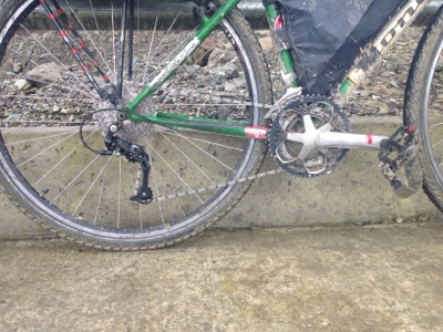
That's Tam's (former) derailleur in multiple pieces

We were making good progress pedaling slowly through the muck when I heard a wrenching sound from Tam's bike. She ground to a halt, her chain having seized up with gritty mud and broken off the derailleur, pulling it into the spokes and bending the part of the frame that the derailleur is attached to, the derailleur hanger, in the process.

Yikes!

You may recall that this has happened before. A year ago we were slogging through similar mud in northern Alaska when the exact same thing happened to Tam, only she was able to stop before the derailleur broke. With the help of other cyclists and a giant wrench from a truck stop (the only anything for many miles around), we were able to bend everything back into shape and continue riding to Fairbanks, where Tam, expecting the formerly bent derailleur to break at any moment, picked up a new one. But, miraculously, it never broke. It lasted all the way to here, and the new derailleur was still new and in Tam's bag! Even more miraculously, this break happened right in front of a mechanic's shop and a restaurant! Normally there isn't much along this road; these services were set up temporarily to support the construction. We couldn't believe our luck.

With the help of some friendly construction guys, we removed the broken stuff, bent the derailleur hanger back in line (more or less), installed the new derailleur, and ate a warm lunch, all in under an hour!

Working on the bike

Success! New, shiny derailleur

Feeling proud of ourselves, we pedaled onward through more rain, finding the pavement just two kilometers from where we had broken down. From there the going was fast, but now, above 9,000 feet, the cold rain and wind were becoming a challenge by themselves. Tam, I'm sure, was counting the days until she would receive her new rain jacket in Quito, which would surely be more waterproof than her current hoodless windbreaker.
Pavement, yessss

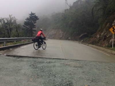
We had to stop and wait awhile at around 10,000 feet for a landslide to be cleared, and upon starting again were just kind of fed up with the cold wind and rain. We were fully in the clouds, no sign of a break in the weather, so upon finding a small restaurant, we stopped. Inside we found laughter, warmth, and the most delicious hot chocolate and buñuelos in the world (a buñuelo is a fried ball of corn flour and cheese). The happy folks inside, Lucila, Wilson, and Natalie, took good care of us, and when I asked if we could camp outside, Lucila looked shocked; she had already prepared a bed with about fifteen blankets! We played some music then drifted off, listening to the wind howl outside.

Lucila and Natalie

Restaurante La Cascada, an unassuming little outpost, is worth a long stop if you're in the area!

The next morning we said adios to our new friends and continued up to the top of the pass. There were no fences next to the road at the top, no farmland, just high elevation páramo, a marshy ecosystem similar to moors.  
Frailejones hiding in the mist

We soon descended again into the land of cows, climbing up another small pass before finally dropping way down towards Popayan. Stopping for lunch in Totoro, we started talking with the people in the restaurant and soon were telling about our exotic North America and learning the local indigenous language, which was apparently the first in South America, according to one guy. We ended up chatting for hours. 
The restaurant crew

Ema tried my helmet on for size 

Back on the road, the descent to Popayan took no time at all and we found ourselves soon at the home of Ronald, whom we had contacted through Warmshowers. Maybe the nicest person ever (tied with all the people we have met over the past few days), Ronald welcomed us in. Tam hasn't been feeling well, so we are staying the next day as well at his place in Popayan.

Popayan: The White City

Route notes:
- Paved from La Plata for a number of kilometers, then decent dirt to Inza. Construction trucks but little other traffic. After Inza, rutted and deep mud for a bit, tough but mostly rideable with medium to thick tires, motivation, and okay conditions. Paved about 10km after Inza, some bumpy dirt again near the top of the pass, paved on the first downhill, bumpy dirt again on the next big uphill, then paved to Popayan.


Tuesday, June 16, 2015

Into the Cordillera Central, June 14th-16th

Neiva-Palermo-La Plata

June14
We weren't planning to take a rest day, but it was so hard to leave Erika and Camilo that we spent the day cooking and reading instead of riding.

June 15th
Happy birthday, Dad!
It takes a little while to get going in the morning; somehow our small amount of stuff has expanded everywhere. Too soon it is time to say goodbye to our amazing hosts. We were so lucky to have the opportunity to spend some time with Erika and Camilo. We can't thank you guys enough!

Heading out of town there is more traffic than we expected on our small road, but there are a lot of cyclists out and the cars seem accustomed to it. All are very respectful of us. Once we pass the first town of Palermo, the traffic dies down to almost nothing and our road winds up and through the mountains. It's a beautiful and peaceful ride.

We stop in a small town to enjoy some cheese and our homemade bread for lunch, then continue on. It's hot, but in many places trees form an archway over the road, and the shade keeps us cool. The road turns from paved to gravel, but the surface is still relatively smooth and we make good progress. I like that the dirt is streaked with so many colors: gold, blue, black, orange, red... we must be in a mineral rich area.

When it gets late and we're tired of climbing (we've been going up most of the afternoon) we ask to set up camp in a farmer's field. The family happily grants is permission and we find a spot far from the road and barking dogs.

June 16th
We're both feeling a bit under the weather this morning so we end up getting another late start. Luckily we don't have too far to go today. Our road becomes paved again just outside of our first town. As we climb a giant hill, we watch kids playing outside on a big yard outside of the school. It's 9:30 on a Tuesday. Later, around 11:00, we see kids at another school all playing outside. School here gets out around 12:00. Clearly rural education in Colombia needs a lot of help.

Outside of town our road turns to dirt once more. Happily, the surface is good quality and the mountains are beautiful, mostly untouched by farmers. Their streaked cliffs and overhanging vegetation remind me of an ice cream volcano cake that I made once for my birthday. We climb up and up and finally reach the top of the pass. Woohoo!

It's hard to see from the picture, but this is a car driving by with the guy in the passenger's seat holding his horse by a rope through the window. Farming meets 21st century. 

On the way down it's not too long before we hit pavement. But wait, it's still under construction. In particular a bridge is under construction and the road goes through a rather wide river. There is a small and rather unstable looking plank set up as a pedestrian crossing. Danny tries to ride across and immediately his shoes are soaked as his bike sinks into the riverbed. I just take off my shoes and walk across.
Yep- that's our road. Check out the "pedestrian crossing" on the left side.

For lunch we enjoy huge plates of eggs and rice. After some relaxing in the cool restaurant, we get back on the road for our last 25 km. Thankfully our road is again well shaded by trees and is beautifully paved.

When we reach the town of La Plata we enter into a chaos of motorcycles and other traffic who seem to have little regard for the traffic lights. After a bit of confusion, we find the centro and meet up with Juan Carlos, a friend of Erika and Camilo who has agreed to have us for the night. Juan Carlos, we soon learn, is a real revolutionary. His parents started a recycling program in this city and he now works on that program along with other environmental education initiatives. When we ask him what he does in his free time he says simply, "politics." He explains to us, in simple terms, that he's trying to improve conditions for the poor in Colombia. The house is plastered with pictures of Che Guevara and radical rap music bumps from the stereo. We spend a relaxing and interesting evening with Juan and his friends Isabel and Vanessa.

Other notes of interest:
New record number of people riding on one normal sized motorcycle: 6 
Strangest motorcycle passengers seen yet: two women and a pooping goat.

Route Notes
- Neiva to La Plata via Palermo: some traffic until Palermo then hardly any until the merge with highway 24. Paved except for about 30 km of very smooth dirt/gravel from Teruel to Pacarni

Sunday, June 14, 2015

Flats and Fake Deserts, June 11th-13th

Girardot-Espinal-Guamo-Natagaima-Aipe-Villavieja-Neiva

June 11th
The morning dawns rainy and grey 
We smile and hope it stays that way 
The cloud cover limits the heat 
That we are desperately trying to beat
Our road is flat and the shoulder wide 
Making for a smooth and easy ride
A few pedals and we start to fly
Suddenly the kms are passing by
We glide past farms and cows
Colombians have planted as much as the soil allows
The valley bordered by mountains tall and green
I'm sure they're further than they seem 
Occasionally we pass some chickens and turkeys 
Or cross a river that is brown and murky 
Eventually the clouds clear and the sky turns blue
We put on more sunscreen and pedal through. 

Our road

The afternoon continues much the same as the morning. We pass multiple stands selling hand-woven sombrero type hats, clay pots, piggybanks, and wind chimes. For whatever reason these items seem to be the local specialties. Never in Colombia will you see just one stand selling something. There will always be at least five (more often more) selling the exact same thing, for the same price. It is still a mystery to us how they make any money. Maybe they don't. 
The "towns" we pass are just tiny groups of houses. We stop to camp in a dry field. The family who owns it is very friendly and tells us that if we need anything, just ask. 

June 12th
In the morning we try to get an early start to beat the heat, but today there are no clouds, thus the sun is already burning bright at 6 am. Our plan for today is to get to the desert of Tatacoa, a unique geological formation that several people have recommended to us. To get there we need to cross to the other side of the River Magdalena, and after talking to a few people along the road, we decide that the best option is going to be to take a boat from Aipe. 
Aipe is a cute town with good grocery stores and fruterias. We stock up on yummy food for the next day or so. Finding the boat to take us across the river is a bit of an adventure. Here's how it goes. 
1. Ask nice lady at grocery store how to get to the desert.
2. Follow her directions, then ask random guy on the street if we're going the right way.
3. Descend down steep hill to a branch of the river.
4. Take bridge across it.
5. Ride dirt trail through some fields and arrive at second, smaller bridge. 
6. Choose between two small dirt trails that both lead away into pastureland.

Two roads diverged in a yellow wood...

7. Choose left trail because it looks more traveled.
8. Follow trail until it ends at a flooded field.
9. Return to first bridge and ask the different random guys we meet there how to get to the desert.
10. Go back down dirt trail, cross second bridge, and take right hand fork. (Turns out we should have followed the example of Robert Frost)
11. Ride tiny dirt trail past a bunch of cows.
12. Reach a red gate, open it, and go through it.
13. Ride on another tiny trail by the river.
14. Reach a rocky bank along a big river.
15. Wait for motorized canoe that is coming our way! 


Our boatman

The boat ride itself was only 5 minutes or so, and thus we made it across the mighty river Magdalena! We crossed the same river weeks ago to reach Mompox; it is big here, but nothing compared to its size in the north.
On the other side we order some fresh fruit juices at a restaurant and spend a little while avoiding the mid day heat. Then we ride out of town and off towards the desert. This road has been newly paved and it great for riding! We're immediately struck by how green it is, and that somehow, there are still cows out here. 

Our winding desert road

Once in the desert we meet some wonderful people from Medellin who have come out here for the weekend with an astronomy club. Apparently the desert is one of the best places in Colombia to see stars. They kindly invite us to join their astronomy party in the evening.
Side note: they also explain that the Desert of Tatacoa isn't really a desert, it's just a really, really dry forest. That explains all the greenery. 
For the rest of the afternoon we hike around a bit through the crazy formations, and then pay $2 each for the use of a cold swimming pool at one of the little hostels. It's amazing! 


Cool formations! The soil is extremely dry, flakey, and fragile.

A cute kestrel on a giant cactus

Impressive shadows

Exploring 

Hello cactus

All of the soil used to be as high as this tower, but slowly it was worn down by erosion and now we have these crazy formations. 


Once the sun goes down we spend hours enjoying the constellations, and have the opportunity to see Jupiter, Venus, Saturn, and various globular clusters through a telescope. The night sky is spectacular. 
So many thanks to our new friends from Medellin for an incredible evening! 

June 13th
One of my closest friends from high school today is getting married today! I wish I could be there with her to celebrate. Congratulations and best wishes to Emily Hisey and Zack Palchak. :-)
We'v decided that the desert of Tatacoa is Colombia's version of BLM land in the States. You can come here and do whatever you want. Throughout the night we listened to motorbikes zooming by on the road, a car going by and honking its horn loudly every 2 seconds, other people camping and counting loudly and repeatedly from one to ten, donkeys braying, dogs barking, roosters crowing, etc. Since sound carries well across wide open spaces, we had quite the symphony. 
We still manage to wake up pretty early in the morning, determined to make it to Neiva. After a short bike out of the desert, we turn left onto a road that we will take into the city. The road, much to our surprise is paved! There is next to no traffic and the sky is completely cloudy, even a bit rainy at times. This makes for excellent riding! When we reach the outskirts of the city, the road expands and it's not too difficult to navigate the traffic. We've made excellent time. By 12:00 we've already done our shopping and figured out where to meet our warmshowers host. 
This begins a lovely afternoon. We meet Erika at her place of work, a small business that is working to promote peace and social development in Colombia. Erika is a wonderful person. She's is open, welcoming, happy, and so excited to have cyclists staying at her and her boyfriend's place because they just signed up on warmshowers. Immediately I feel like we are best friends.
She takes us out to lunch with one of her coworkers, Cesar, and we enjoy a typical Colombian meal with soup, rice, eggs, french fries, and even a bit of salad! 
In the afternoon I do some cooking and Danny goes on a bus adventure to find a part of our tent that we accidentally left behind camping in a field a couple days ago. Luckily the bus travel isn't complicated and Danny is able to find the part! 
We spend a fantastic evening talking to Erika and Carlos, our amazing hosts, and Boris and Charlotte, two French cyclists who are also staying here. They have just biked up from Argentina and have tons of stories and information to share with us!

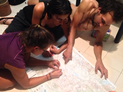
One of our favorite pastimes, looking at maps! 
 
Check out this midnight snack! 

So many thanks to everyone for delicious food and interesting stories and advice. 

Route and Area Notes
- Girardot to Neiva: paved, big shoulder the whole way. Not too much traffic but increasing near cities.
- Desierto de Tatacoa: accessed from Villavieja, 4 ways to enter. 1) paved overland route from Neiva, 2) rough (but, people told us, not too rough, whatever that means - we didn't take it) overland route from Pueblo Nuevo, ~30km north of Aipe, 3) by ferry from Pata, about 20km north of Aipe, 4) ferry from Aipe. See Tam's detailed notes above for directions to the river from Aipe. The motocanoa was COP$3000 per person, and I think it's just one guy going back and forth, so ask around to see if he's shuttling people. If not, Pata may be a better option. The road to/from Neiva is a great ride, no traffic (except right next to the city) and good road condition. No shade, either, so go early. 
- The observatory in the desert is about 6km east of Villavieja. The pavement ends there. The observatory is closed on the weekends, apparently. Just after are a number of posaderas and restaurants, and about 7km past those is another natural attraction, Los Hoyos, which is apparently some natural pools. Saturno, one of the first few little places on the left after the observatory, rents its pool for COP$4000 per person for the day. It and all the other places have zonas de camping, but we just wild camped. 

Wednesday, June 10, 2015

To Bogota... and Beyond! June 3-10

Villa de Leyva-Ráquira-Guachetá-Lenguezaque-Ubate-Bogotá-Mosquera-La Mesa-Girardot

Our night in Villa de Leyva was vastly bettered by local empanadas and garlic-olive bread, and by meeting two brothers: German, an architect designing a hospital here, and Angelo, a classical guitarist.  I can't say I've ever had a better time making pasta, with a feast for the ears emanating from Angelo's deft fingers.  
He strummed and plucked a long mix of classic rock- Kansas, Led Zeppelin, Simon & Garfunkel- the melodies and the chords at the same time, then launched into a series of technical and romantic songs.  The pasta tasted terrific, and we enjoyed chatting with the two of them for a bit as well.

The next morning, we headed south on some well-surfaced roads, taking advantage of an arepa-specializing restaurant in Tinjaca and enjoying the colorful handicrafts of Raquira.  
Cheese arepas, Colombia's version of the quesadilla/pupusa/grilled cheese

The whole area appeared to have been influenced in a positive way by the colonial draw of Villa de Leyva.  After Raquira, the road turned pretty bad, and we began to climb.  

We had hoped to make it to Ubate but were so slowed down by the rough road and giant hill that we only reached Guacheta and decided to stay.  The owner of the hotel we decided to stay in, Gabriel, was really accommodating, even letting us use the kitchen of the restaurant.  In talking with him, he told us that Colombian currency didn't have enough value for him to save up enough to travel.  It's hard to know what to say in this situation, other than acknowledging our good fortune to be from a more developed country, but what I really wanted to point out was that he owns a hotel and was wearing an expensive Lacoste shirt.  Even with the exchange rate in Colombia, his hotel is undoubtedly worth a lot more money than we have spent on this ridiculously long trip, and it's possible to spend much less than we did.  We hear excuses from our American friends, too, all kinds of reasons they can't travel.  Really, all but the very poor have the means to get out there and go, but most put other things first (a career, a family, cable TV, beer, eating at restaurants, heating, basically anything that costs money).  And that's fine -- people can live their lives however they want -- but I wish people would acknowledge their actual priorities rather than simply saying "I can't."

My priority for a few minutes was to find a stegosaurus crossing the road (this is an ad for the "dinosaur park" near Villa de Leyva). This is a stegosaurus, right? It's been a while since I last used my old dinosaur placemat.

While leaving, we gave Gabriel our contact information in the hopes that he would come visit us someday, wherever we end up. Then we biked to Ubate, following relatively smooth and flat dirt roads for the first time in awhile.  Instead of trying to brave the traffic into Bogota, we hopped on a bus in Ubate and found ourselves a short while later in the big city!  Even though we had a map showing some of the many bike lanes in the city (see below for the map), getting around was still a challenge, and we arrived at our friends' place around 5.  Meet Levi and Erin:

They have been teaching in Bogota for the last few months and just accepted a job at High Trails, our former place of work!  A mutual friend put us in touch, and the two of them were kind enough to have us at their place for a few days.  Actually it felt more like our place, because they were out adventuring over the long weekend and left the apartment to us!  We made tons of delicious food, visited almost every bike shop in the city, did a lot of work on the "Where" page of our blog, sightsaw, and did a lot of other random stuff.  Most importantly, we rested our legs for the first time in a while.  Many thanks, Levi and Erin!  See you down the road!

Homemade pizza with salsa for cheesy crust dipping

At the ciclopaseo on Calle 116. Every Sunday, this and some other roads in the city are closed to cars so that people can get outside on bikes, skateboards, or roller blades without worrying about being hit by a bus.

The big old church at the Plaza de Simon Bolivar. Most fun on our trip to the touristy area of La Candelaria was witnessing guinea pig gambling: place your money on the pail that the guinea pig enters, and win big!

We also made a lot of bread. One of Tam's neat loaves:

And one of mine:
I dubbed it "the brain bread."

The best chocolate croissants ever.

After what seemed like just hours after arriving, we hopped back on the bikes and headed out of the city.  We had a fantastic route planned with bike paths all the way, but that plan ended quickly when our riverside trail met an eight lane highway with high medians.  Who designed this bike path?  We found a different way and made it out without ever feeling too overwhelmed.  Even so, it wasn't a fun ride.  The traffic died down a few miles outside the city, but around 4, heavy fog set in, reducing visibility to a few feet.  
With a long descent to hot climates just ahead, we were happy to set up camp in the brisk temperatures of 9,000 feet in a quiet field behind a gas station.

The next morning, we began said descent. Stopping at a restaurant in Anapoima, a ritzy area with country homes for Bogota's elite, we ordered our staple meal, rice and eggs, and the guy offered fruit salad as well.  We hesitantly said yes, hoping to receive a bowl with fruit in it. Instead, we got this:

Fruit salad, Colombian style. Ice cream, yogurt, cheese, mysterious flavored sauces, maraschino cherries, a cookie stick, and some fruit underneath.
From now on, we're sticking to rice and eggs!  Nothing else!

We ended up in Girardot, where we ate some more arepas and I shaved off my beard.
Before:
After:

Route and Bogota Notes:
- Raquira to Guacheta was pretty rough. Rideable, and not so bad as the area around Gambita (see our previous post), but not easy going.  Fortunately the rough part is limited pretty much to the ascent, and the road into Guacheta are better, some parts paved.
- The 45A from Ubate, as seen from the bus, looked awful for cycling. From Zipaquira to Bogota, there was a bike lane every time I looked up from my book. I don't know about the whole way, but definitely at least in parts.
- Getting around Bogota is simple in theory but not in actuality. Calles run east-west, their numbers increasing as you go north. Carreras run north-south, their numbers increasing as you move west.  Bike paths are abundant but sometimes deposit you into a freeway.  My recommendation for getting around: stick to the biggest roads possible that have bike lanes. And use this map.
Email me for a high quality version. This is much better than the Open Cycle Map for Bogota.
- The majority of bike shops in the city are on Calle 68 from Carreras 24-30. There are others on Calle 127 near Carrera 55.  The service we received at most of these shops was awful; probably better to do everything yourself.  We are not bike mechanics, but after realizing that the bike mechanics at the shops aren't either, we watched YouTube videos of the repairs we needed to do, then just asked to borrow the tools.
- Leaving the city through Calle 80 wasn't horrible, but Highway 21 was almost until the intersection with 21 to Soacha. There was room in the bumpy drainage gutter to get off the road if necessary. Traffic for us was exacerbated by construction. If I were to do it again, I would take back roads -- or a bus. The descent to Girardot had trucks here and there but nothing too bad.